The Magnetic Thickness of a Recent Submarine Lava Flow
Data Collected by Autonomous Underwater Vehicle
Spring 1998 — Submarine lava flows and their associated narrow feeder conduits known as dikes constitute the basic building blocks of the upper part of the ocean crust. We are only beginning to understand how lava erupts and forms on the seafloor by flooding topographic lows, flowing through channels or tubes, centralizing into volcanoes, or some combination of all of these. (See Smith/Cann article for a discussion of these volcanic processes.) The style of emplacement along with the extent and volume of individual lava flows and eruption rates are important parameters that help determine the initial properties of oceanic crust, its vertical and horizontal structure, and what processes control the magma supply to the crust.
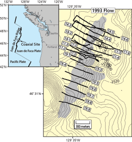
Less than a handful of seafloor eruptions have ever been monitored in real time or near real time, so when a swarm of seismic events showed characteristics of an eruption off the west coast of the US in July 1993, the American science community mobilized to take advantage of this unique opportunity. The seismic activity was initially detected by seafloor sensors on the CoAxial ridge segment of the Juan de Fuca mid-ocean ridge system at 46°15’ N, 129°53’ W, but then over a period of just two days the activity marched 40 kilometers north along a narrow band of the seafloor to center on 46°31.5’ N, 129°35’ W, where activity finally dissipated after a few more days.
Research cruises sent to this latter site discovered a seafloor eruption had indeed occurred, forming a new lava flow up to 30 meters thick, 2,500 meters long, and 400 meters wide. To the north and south of the lava flow, a linear narrow fault-bounded valley, called a graben, was also discovered, oriented along the same trend as the lava flow. This narrow graben is the surface expression of the subsurface feeder conduit or dike zone that fed the lava to this eruption site from the magma chamber located some 40 kilometers to the south.
We were fortunate that the Juan de Fuca region had been mapped relatively recently with modern bathymetric systems and thus repeat bathymetric mapping after the CoAxial eruption allowed the pre-eruption topography to be subtracted from the post-eruption topography to obtain an estimate of the new lava flow’s thickness. Pre-eruption bathymetric surveys are not always available, however, which precludes using differential bathymetric mapping to determine lava flow thickness for many regions. One possible solution is to measure a property that is proportional to the volume of the new lava, such as its magnetic anomaly. Newly erupted lava is thought to be initially highly magnetized before it degrades to less magnetic minerals through sea-water alteration. Highly magnetized lava thus should produce a distinctive magnetic signature relative to the older lava. Individual lava flows are typically thought to be on the order of a few tens of meters thick and a few kilometers long, requiring close-up, near-bottom magnetic surveys rather than distant surface surveys to obtain the requisite resolution for detecting such features. Magnetic surveys also offer some potential advantages over differential bathymetric mapping. Surface ship bathymetry has a relatively large footprint of 100 meters square and a limiting depth resolution of 5 to 15 meters, although near-bottom bathymetric mapping could improve on this resolution by an order of magnitude. Depending on the geometry and density of the magnetic survey tracks, near-bottom magnetic mapping could have both a small effective footprint and the ability to map flows thinner than 5 meters. The magnetic mapping method also has the advantage that it can be done after the lava flow has erupted and does not require pre-eruption surveys.
Six months after the eruption, in late 1993, we used the submersible Alvin to carry out an initial survey of the new floor and found that the new lava flow did indeed have a strong magnetic anomaly associated with it and that the anomaly could be directly attributed to the new lava. For a more extensive survey, I turned to some colleagues here at Woods Hole Oceanographic Institution who are developing small autonomous underwater vehicles (AUVs) as new platforms for science. AUVs are untethered robotic vehicles that can be programmed to operate independently, for example, to execute a series of geophysical tracklines over the seafloor while computing their position, depth, and altitude off the seafloor. The AUV currently under development at WHOI is nicknamed “ABE” for Autonomous Benthic Explorer, and the elegance and simplicity of making measurements from such a platform belies the technological achievements needed to make it possible. (See Oceanus Vol. 38, No. 1, 1995, for a discussion of ABE’s development.)
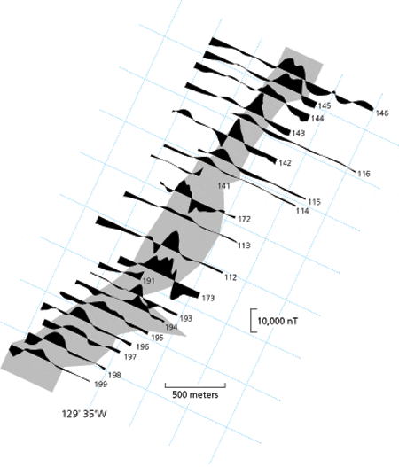
In 1994, we outfitted ABE with a magnetometer sensor to carry out a detailed magnetic survey of the CoAxial ridge lava flow. ABE collected additional data in 1995, providing approximately 35 kilometers of tracklines over the new flow. The surveys cover the majority of the lava flow and provide a broad view of its magnetic field. The new lava flow produces an extremely strong near-bottom magnetic field anomaly of approximately 15,000 nano Teslas (units of magnetic field intensity), which is almost 25 percent of Earth’s main magnetic field of 55,000 nano Teslas. The observed anomaly arises from a combination of the magnetization of the new flow and the topographic effect of the ridge upon which the new flow erupted. The ABE magnetic field data were first corrected for the magnetization of the vehicle and then corrected for the variations in observation depth of ABE.
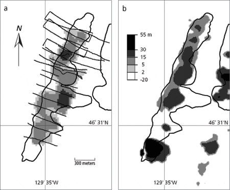
For magnetic anomaly data to provide an independent estimate of flow thickness, crustal magnetization over the old and new lavas must be determined by representative rock sampling. Measurements of rocks sampled by Alvin and Jason revealed the new lava’s magnetization to be about 60 amps per meter on average, while the older surrounding lava has a magnetization of only 26 amps per meter. To estimate lava flow thickness from the ABE magnetic anomaly data, a forward modeling approach allows us to fit the observed magnetic anomaly for each ABE profile by iteratively incrementing the thickness of the new lava and calculating the resultant magnetic anomaly. The final profiles are then translated into a lava flow thickness map (see figure at right) which shows a maximum of almost 30 meters.
This “magnetic” thickness map is remarkably consistent with both the observed flow boundaries and the lava thickness derived from differential bathymetry. A total erupted lava volume of 8.8 million cubic meters can be estimated from the thickness map, which includes a correction estimate of 1.8 million cubic meters for the northern and southern extremes of the flow and the eastern tongue not traversed by ABE. This volume is consistent with differential bathymetry data on the 1993 CoAxial lava flow and represents the volume equivalent of a small Hawaiian eruption. The magnetic thickness map identifies the presence of the 1993 lava flow where it is too thin for detection by the differential bathymetry method. Differential depth measurements are also less reliable in areas of steep slopes because small shifts in navigation can produce artificial depth anomalies (see the overestimated differential depth anomaly in the figure below, where the south end of the eruption abuts the side of the small seamount). Magnetic thickness estimates are unaffected by these bathymetry problems.
The magnetic estimates do, however, have their own set of resolution limitations and problems. The error in the magnetic thickness estimate depends primarily on the estimates of both the old and new lava magnetization. The extent to which magnetization varies within a single flow is not well known, but it is reasonable to assume that the 1993 lava flow has relatively homogeneous magnetization because it erupted as one single flow and cooled relatively quickly. There is greater likelihood of magnetization variation for the older lavas because they may be composed of several flows from different ages and eruption events. By combining error estimates from the measured rock samples of the old and new lava, we obtain an uncertainty in the thickness of the new flow of about 30 percent. It is difficult, however, to estimate how well the magnetic modeling fits the true lava flow thickness because the only constraints are the differential bathymetry thickness data, which represent a spatially filtered and thickness truncated version of reality. Nevertheless, differential bathymetry does provide an upper constraint on lava thickness, and this is compatible with the magnetic thickness estimates.
The ABE survey shows that high-resolution, near-bottom magnetic field surveys can help to quantify the geometry of young, recently erupted seafloor lavas and can provide thickness estimates that are consistent with other observations such as differential bathymetry. Magnetic fields offer some advantages, for example, in mapping lava flows that are too thin for detection by the differential bathymetry method and where steep topography causes the differential bathymetry method to be unreliable. The most important advantage, however, is that magnetic surveys can be undertaken after an eruption, removing the need for preexisting data over the site.
For magnetic anomaly data to provide independent estimates of flow thickness, crustal magnetization over the old and new lavas must be determined by representative rock sampling. Finally, the magnetic survey provided an opportunity to test a newly developed autonomous underwater vehicle. AUVs represent the newest wave of technology that promises to revolutionize oceanography and marine geoscience and make the oceans more accessible to scientific study. Just as Alvin, deep-towed sensors, camera sleds, and remotely operated vehicles such as Jason revolutionized the way geologists and geophysicists viewed the seafloor in the 1980s, so now AUVs are poised to make as big an impact in the 21st century.
The research described in this article, as well as the development and operation of ABE, were supported by the National Science Foundation.
Slideshow
Slideshow
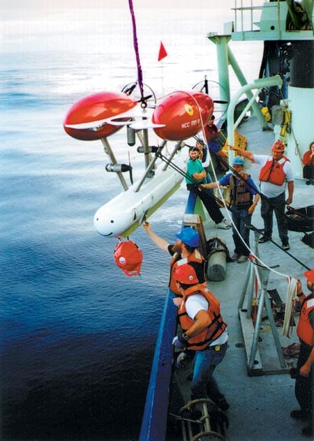
- Scientists and crew launch ABE from Atlantis II for a 1995 magnetic field mapping run on a new Juan de Fuca Ridge lava flow.
- Bathymetric map of CoAxial lava eruption site located on the Juan de Fuca Ridge (see inset). The gray shaded region represents the extent of the new lava eruption. The bold lines are the tracks of the autonomous vehicle ABE.
- Shaded areas on plot show strong magnetic field anomalies measured by ABE over the new lava flow.
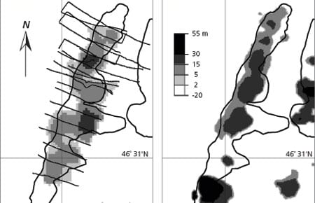
- Two maps compare (a) the lava thickness determined from the magnetic field measurements compared to (b) lava thickness determined from differential bathymetry. The bold outline is the actual observed extent of the new lava flow.
Related Articles
- How did the ocean remain so quiet during Tonga’s eruption?
- Spock versus the volcano
- In Search of the Pink and White Terraces
- ROV Jason Images the Discovery of the Deepest Explosive Eruption on the Sea Floor
- Undersea Asphalt Volcanoes Discovered
- Deeply Submerged Volcanoes Blow Their Tops
- Robot Paints Stunning Map of Deep-sea Volcano
- Plumbing the Plume That Created Samoa
- New Wrinkles in the Fabric of the Seafloor

