Indian Ocean’s Atlantis Bank Yields Deep-Earth Insight
I never imagined I would spend six weeks of my life “wandering around” the seafloor exploring an 11 million year old beach, and it never occurred to me to look for a fossil island. But that’s what I did, and that’s what we found on two research voyages separated by more than a decade.
Spring 1998 — I never imagined I would spend six weeks of my life “wandering around” the seafloor exploring an 11 million year old beach, and it never occurred to me to look for a fossil island. But that’s what I did, and that’s what we found on two research voyages separated by more than a decade.
But, first, a bit of history: During World War II, Princeton mineralogist Harry Hess convinced US officials to keep Navy ships’ echo sounders running as they crisscrossed the Pacific. Hess, a captain and later admiral in the Navy, even managed to have his men bring back rock samples when they returned to the ship after Pacific Island landings. We not only won the war, but also identified the mid-Pacific mountain range now known as the East Pacific Rise—a discovery that proved fundamental to the then developing theory of plate tectonics.
Thus began modern marine geology and geophysics. Prompted by Hess’s discoveries, when peace returned, American scientists initiated a systematic study of this little known region. One of the first results was the discovery that the ocean crust appeared to present a consistent, layered seismic structure composed of sediments (layer 1 at the seafloor) followed by two layers with rapidly increasing sound velocity, and then a reflector, dubbed the Moho after the its discoverer, a Czechoslovakian seismologist named Andrija Mohorovicic. What surprised scientists was the Moho was found at a very shallow, nearly constant depth of 6 to 7 kilometers, and that seismic layers 2 and 3 above also appeared uniform in the oceans, whereas this boundary ranges from 35 to 60 kilometers deep beneath continents.
This led to a great debate about the nature of the Moho beneath the oceans and the composition of the layers above it. Hess proposed in his now famous 1962 paper The History of the Ocean Basins * that the Moho was an alteration front created by hydrothermal solutions converting the earth’s mantle to a lighter rock known as serpentine. Serpentine forms by hydration of the primary mantle rock peridotite, which is named for the gem stone peridote (the most common mineral, known to scientists as olivine). The uniform depth of the Moho, then, represented the upper temperature and pressure limit of peridotite and olivine as stable elements beneath the ocean ridges. Hess thought Layer 2 was the volcanic carapace formed as lavas erupted above the hydrothermally altered mantle rock.
This theory was rejected, however, because laboratory experiments on serpentine failed to produce the exact acoustic velocity characteristics inferred for seismic layer 3. Instead a model where the Moho was the crust-mantle boundary, with layer 3 composed of the rock known as gabbro overlying the unaltered mantle peridotite has become the generally accepted paradigm. Gabbro is a coarse grained rock similar in composition to the basaltic lava that erupts from submarine volcanoes. This rock is found exposed on land where deep layers of the earth have been uplifted onto mountain ranges and exposed by faulting and erosion. It is believed to represent the frozen remains of magma chambers where lava rising out of the earth’s interior pooled deep in the crust. Gabbro is also found in “ophiolite” complexes, bits of fossil ocean crust and mantle commonly found on land in tectonic plate collision zones and in island arcs (see map in Peter Kelemen article). There it underlies extrusive pillow lava and sheeted dikes and overlies mantle peridotite; it is also believed to represent the remains of magma chambers. The ophiolite sequence of pillow lavas–dikes–gabbros–periodite provides a convincing match to the seismic layering.
However, ophiolite crust is generally much thinner than the seismic crust in the oceans, and the lavas there often have quite different chemical compositions than those on the seafloor. Do ophiolites represent broader ocean crust characteristics? Hess and geophysicist Walter Munk (Scripps Institution of Oceanography, University of California, San Diego) cooked up the idea of drilling a hole into the earth’s mantle and sold it to a group of their colleagues, known as the “American Miscellaneous Society,” who in turn sold it to Washington: Drill a hole into the mantle all the way through the ocean crust. Dubbed “Project Mohole,” the idea eventually foundered on the rocks of the congressional budget office in cost overruns and ballooning budgets. It was later reborn, however, as the successful Deep Sea Drilling Project and its successor, the Ocean Drilling Program. (See Oceanus, Vol. 36, No. 4 for “An Abridged History of Deep Ocean Drilling.”) These programs have incrementally sought to drill deeper, first through the sediments, then through layer 2, which proved to be, as thought, pillow basalts and sheeted dikes, the remains of the lava that erupted onto the seafloor and its feeder channels. But there the drilling stopped. The material being recovered was too brittle, too broken, and it seemed too difficult to go deeper.
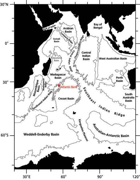
In 1984 my colleague Jim Natland (Scripps) and I proposed using tectonic windows in the ocean crust to get to the deeper rocks. Simply go someplace where Mother Earth had done a lot of work for us by tectonically stripping off the shallow layers, and start deep. In 1986, we surveyed the seafloor south of the island of Mauritius at a great oceanic transform fault named Atlantis II Fracture Zone, looking for a place to drill. The survey produced a map of a 200-kilometer long, mid-sea mountain range flanking the fault. In the middle of these mountains was a remarkable flat-topped peak rising up some 5 kilometers from the seafloor. On the walls of Atlantis Bank, as we named the feature, we sampled gabbro and peridotite, proof that drilling here should be productive.
Then, in 1987, Jim and I returned to Atlantis Bank aboard the drill ship JOIDES Resolution along with several WHOI colleagues including co-chief scientist Dick Von Herzen, who had backed the project from the beginning. Over 16 days of drilling we recovered 437 meters of gabbro from a 500 meter hole, making Hole 735B the most successful hard rock hole ever drilled in the oceans. Although we expected to find gabbro in the lower ocean crust, these rocks still produced a lot of surprises. Scientists had long debated whether the lower crust was crystallized from one great steady-state magma chamber many kilometers across lying beneath the ocean ridge. There was no proof for that here—rather there were many small intrusions, hundreds of meters in dimension, not kilometers. Crystallization here was ephemeral and short-lived. And, a great surprise—the magmas deep in the earth were moved around as the rocks deformed when the ocean crust stretched and ripped apart during seafloor spreading. The crust simply looked a lot different than we expected.
The Indian Ocean is a tough place to get to. It took 10 years to get back. Finally, Jim (now at the University of Miami) and I returned last fall aboard JOIDES Resolution as co-chief scientists and started drilling again to deepen Hole 735B. We drilled another kilometer, and surprise—everything changed again.
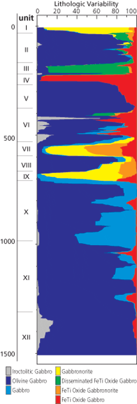
After careful study, the results showed that the deep ocean crust is compositionally zoned. Its upper layers are enriched in iron and titanium. In the lefthand figure on page 30, this is reflected in a change in the amounts of different rock types. Many large gabbro intrusions on land are also compositionally layered, but not this way. In this piece of ocean crust, the layers are created as tectonic forces drive the last liquid, with iron and titanium in solution, out of numerous small magma intrusions when they solidify—pushing it from the lowermost layers upward to “freeze” at the top of the section. Our discovery of this “synekinematic igneous differentiation” reveals a whole new process never before dreamed of—unique to ocean ridges.
In the 10 years we had been absent, British colleagues led by Tim Minshull (Cambridge University) had been by to conduct a seismic experiment, which showed that the Moho beneath Atlantis Bank was some 5 to 6 kilometers down. This was much deeper than expected or seemed reasonable in an area where the ocean crust was believed considerably thinner than the usual 6 or 7 kilometers, and where shallow seismic layer 2 (1.5 to 2 kilometers) was already gone.
Well, where was the mantle here anyway? If it were on the walls of Atlantis Bank, then the Moho beneath wasn’t the crust-mantle boundary. That’s what we set out to find in spring 1998. To do this, Paul Robinson (Dalhousie University), Chris MacLeod (Cardiff University), Simon Allerton (University of Edinburgh), and I organized an international expedition on the British Antarctic Survey ship James Clark Ross. Using British Geologic Survey rock drills and the Canadian remotely operated vehicle ROPOS (Remotely Operated Platform for Ocean Science), we went back to see if we could find the crust-mantle boundary on the wall of the transform, and to map out the great gabbro massif through which we were attempting to drill. What we found was more surprises. We did find the crust-mantle boundary—outcropping on the side of Atlantis Bank—only a few hundred meters deeper than where we stopped drilling. So it appears the Moho is an alteration front, as Harry Hess once supposed, at least in this one spot in the ocean. And we did, with our British and Canadian colleagues, map out an enormous block of gabbro over the top of the bank—proving that the crust here is relatively intact and not a great tectonic jumble. But we also found a fossil island.
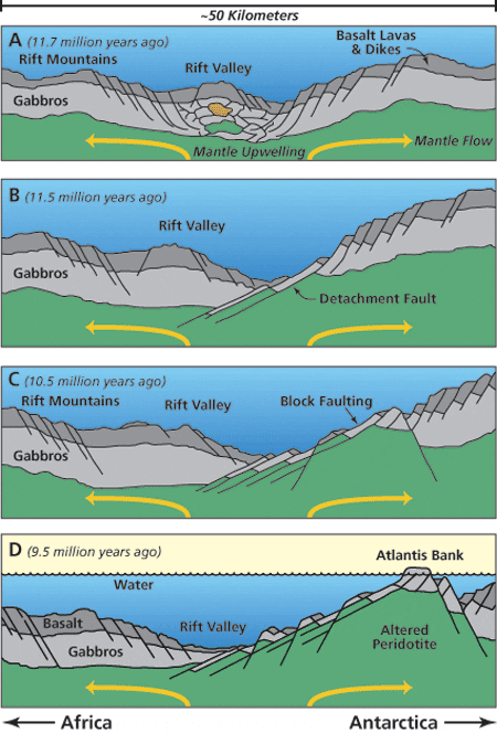
And what about that fossil beach? About two- thirds of the bank is covered by limestone, with ripple marks, just like those in the sand at a modern beach. However, these were “frozen,” lithified as what was once an island sank beneath the waves millions of years ago. There are little pot holes ground into gabbro rock, still partially filled with pebbles and sand, and headlands and fossil seastacks (isolated erosional remnants of the island). No beach umbrella, but an old rotting fishing net—the place had a very large population of lobsters, crabs, sharks, sea fans, siphonophores, sponges, and other critters. It seems that long ago, the whole massif popped up out of the earth some 6 or 7 kilometers at the intersection of the Southwest Indian Ridge and the Atlantis II Fracture Zone to rise above sea level. This great tectonic island with an area of at least 25 square kilometers then slowly subsided back beneath the waves to its present position some 700 meters below the sea surface. It is a remarkable place, both for its modern biologic community and its unique fossil island characteristics. Flat topped seamounts called guyots are well known in the Pacific. They are submerged volcanic islands whose tops are worn away by wave action as they sink beneath the sea surface. But this is the first tectonic guyot anyone has ever studied. And with it comes a unique paleontological record. Between the many seastacks, boulders, and ledges of gabbros, we deployed our short, over-the-side rock drills—and came back with a lot of limestone in addition to the gabbro we sought. There were fossil clams, snails, a limestone made of sea urchin spines, and a kind of limestone known as oolitic, something that forms in lagoons. But they’re all now 700 meters down. Jim, formerly a Moho chaser like myself, found it so fascinating that he has converted himself into a carbonate sedimentologist to explore the mysteries of that fossil island.
This research was funded by the US National Science Foundation with additional support for the author from WHOI’s Van Allen Clark, Jr., Chair. International support was provided by the Canadian Natural Sciences and Engineering Research Council and the British Natural Environment Research Council for remotely operated vehicle and rock drilling operations at Atlantis Bank aboard RSS James Clark Ross.
Henry Dick first came to Woods Hole Oceanographic Institution from Yale University in 1975 as a postdoc with Bill Bryan of the Geology and Geophysics Department. He has been a Senior Scientist since 1990. He has a remarkably dedicated wife named Winifred and three small children, Helene, Spencer, and Lydia, who think their daddy goes to sea too much. He’s promised them he won’t even look at the ocean for at least a year, much less get his feet wet—after his next cruise this fall!
Slideshow
Slideshow
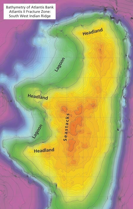
 Five-meter bathymetric map of Atlantis Bank created by WHOI scientist Maurice Tivey from the James Clark Ross echo sounding tracks in collaboration with the other scientists on the cruise. The extraordinary high-resolution map shows the very top of Atlantis Bank with the wave cut platform and the precipitous sea cliffs to either side. One can see old headlands and seastacks in the image, as well as the great arcuate fossil lagoon on the west side where oolitic limestones were dredged.
- Lithologic column compiled by JOIDES Resolution scientists showing the varia-bility of lithologies downhole and the gradation from predominantly oxide-rich gabbros at the top to olivine-rich gabbros at the bottom. The figure was constructed by using a running average of the different lithologic units drilled (almost 1,000 in all).
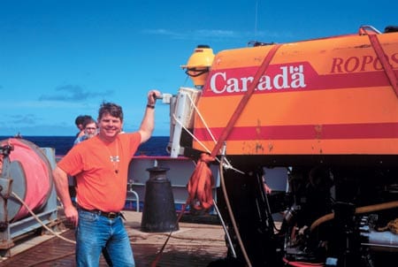
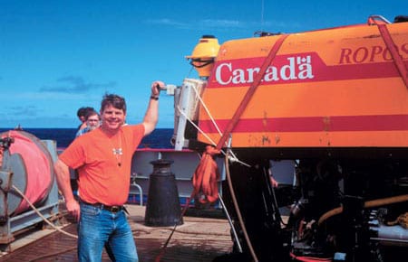
- Author Henry Dick standing next to the Canadian ROV ROPOS on site in the Indian Ocean.
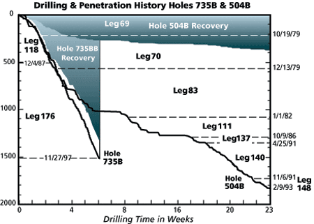
- Drilling results for the two most successful hard-rock holes in the ocean crust: Hole 735B penetrated the lower ocean crust formed beneath the Southwest Indian Ridge and Hole 504B the upper ocean crust formed at the Costa Rica Rift in the eastern Pacific. Note that while Hole 504B is deeper, it took nearly four times as long to drill, and only 18 percent of the rock drilled was recovered while some 87 percent of the rock drilled was recovered from Hole 735B.
- Highly productive drilling on Atlantis Bank in the Indian Ocean gave scientists a surprising new look at the lower ocean crust.
- Hypothetical model for the unroofing and uplift of Atlantis Bank to sea level from beneath the Southwest Indian Ridge from the Scientific Results Volume of the Ocean Drilling Program (Leg 118). Once uplifted, the island then submerged as the ocean crust on which it sat cooled and sank over the last 10 million years.
Related Articles
- How did the ocean remain so quiet during Tonga’s eruption?
- Spock versus the volcano
- In Search of the Pink and White Terraces
- ROV Jason Images the Discovery of the Deepest Explosive Eruption on the Sea Floor
- Undersea Asphalt Volcanoes Discovered
- Deeply Submerged Volcanoes Blow Their Tops
- Robot Paints Stunning Map of Deep-sea Volcano
- Plumbing the Plume That Created Samoa
- New Wrinkles in the Fabric of the Seafloor

