 This article printed in Oceanus Summer 2026
Estimated reading time: 6 minutes
The water was clear and black, true to its namesake. Several miles off Turkey’s Black Sea coast aboard the R/V Northern Horizon, Dwight Coleman was monitoring the video feed from the remotely operated vehicle Little Hercules.
As chief scientist of an institute for exploration team led by Bob Ballard, Coleman was looking for evidence of ancient shipwrecks—working from a theory that the Black Sea’s famously low-oxygen water below 300 feet (nearly 100 meters) would preserve ships and artifacts for thousands of years. In the year 2000, that idea was still mostly unproven. However, with rapidly improving underwater imaging technologies, he and his colleagues were hoping that the missing puzzle pieces of ancient Greek, Roman, and Byzantine trade routes might finally be revealed.
At about 1,000 feet (305 meters) deep, a long, ghostly shape appeared on Coleman’s video monitor. As the vehicle veered closer, details emerged: rope lashing around an upright mast, a rudder and tiller still attached to a streamlined wooden hull. Later estimated at 1,500 years old, this was the best-preserved ship of antiquity discovered at the time. It was also a “defining moment” for Coleman, who now serves as Woods Hole Oceanographic Institution’s director of ocean imaging.
“As an ocean scientist and geophysicist, you’re a little disconnected from the human element,” Coleman acknowledged. “So, by studying shipwrecks, you’re making a human connection. People died on this ship, and this was how people traded goods back and forth in ancient times. When you can tell that story, I think it resonates with a much larger audience.”
In the decades since that Black Sea discovery, Coleman has embraced the power of ocean imaging technologies to tell the story of the deep sea to diverse audiences. At the helm of University of Rhode Island’s Inner Space Center, he led Ocean Exploration Trust expeditions at sea and through telepresence, providing a visual portal to the depths to anyone with an internet connection. With the evolution of underwater robotic technologies and web-based platforms, these efforts created an unprecedented level of access to the most remote and understudied places on Earth.
“The ocean is a deep, dark place that’s very poorly understood, and we don’t have a lot of high-quality imagery to illustrate the environment down there. I think a really powerful way to move our science forward is to visualize it better,” said Coleman.

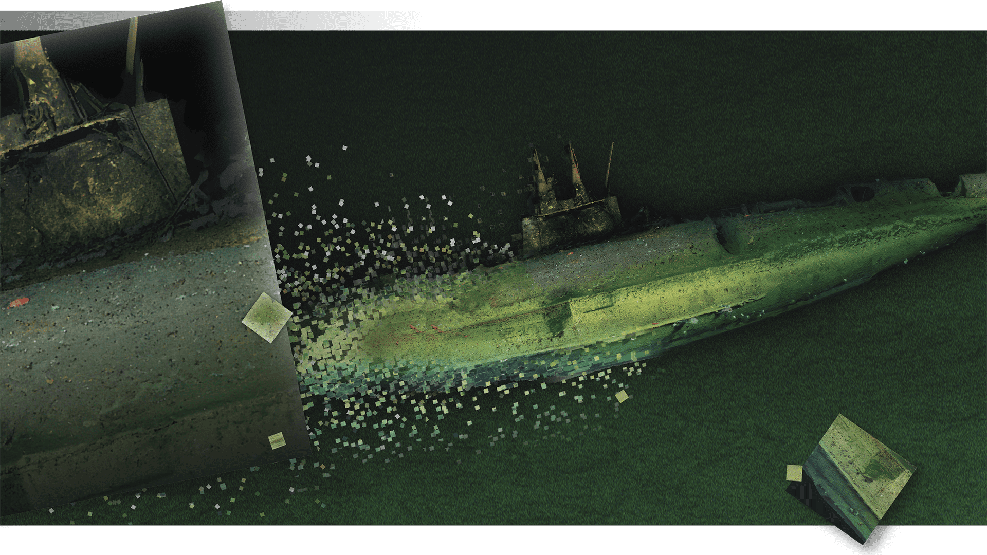
Since coming on board at WHOI in October 2024, Coleman’s focus has expanded to integrating optical and acoustic technologies on autonomous underwater vehicles (AUVs) to improve deep-sea exploration and discovery. Last year, he took part in an interdisciplinary mission with the U.S. Navy and Naval History and Heritage Command to survey the USS F-1 submarine, which was lost off the coast of San Diego in 1917. Combining the multibeam and sidescan sonar mapping capabilities of AUV Sentry and high-resolution images from five cameras aboard the human-occupied submersible Alvin, Coleman’s team used photogrammetric software to create stunning 3D models of the sub. After 108 years, this never-before-seen imagery provided closure to the families of the 19 sailors lost at sea—and shed light on how animals colonize human-made objects on the seafloor.
Building on the success of the F-1 survey, Coleman later surveyed an area where two aircraft had crashed off the coast of Oahu during World War II, this time with a REMUS 600 AUV. Traversing a roughly 10-mile (16-kilometer) quadrant like a lawnmower, the vehicle covered the search area three times in just seven days, generating high-resolution maps of one wreck and confirming that nearby debris was not from the second missing plane. All this was accomplished after the aircraft spent more than 80 years at 340 feet (104 meters) below the surface.
For a researcher used to surveying the seafloor with camera systems towed behind a ship, working with untethered underwater robots is a “game changer,” according to Coleman.
“WHOI does deep submergence exploration better than anyone in the world, so it’s great to see how we can up our game by combining our mapping and imaging capabilities,” he said.
“WHOI does deep submergence exploration better than anyone in the world, so it’s great to see how we can up our game by combining our mapping and imaging capabilities.” —Dwight Coleman, WHOI Director of Ocean Imaging
From ancient shipwrecks and gushing hydrothermal vents to seamounts studded with centuries-old coral, deep-sea imaging efforts have brought the most incredible, inaccessible wonders of our ocean planet to the surface. As oceanographers push to create high-resolution acoustic maps of the entire seafloor (only about 27% has been mapped to these standards so far), these visuals provide critical ground-truthing, confirming the types of rocks and animals that are not possible to interpret from acoustic backscatter. But as technologies continue to evolve, researchers will have more and more footage to review, photos to stitch together, and features to catalogue. In the mind-boggling vastness of the deep sea, making sense of multiple terabytes of visual and acoustic data per dive is enough to make any researcher’s head spin. And that, Coleman said, is where artificial intelligence plays an important role. Integrated into a vehicle’s software, AI can identify potential targets on the seafloor and investigate them in real time, or categorize organisms and geological features from video footage, helping make the most of precious ship and survey time.
“You can try to understand what you think might be there, but you don’t really know for sure until you get your eyes down on it,” he said. “It’s like opening a present on Christmas Day: you’re not sure what you’re going to get. I think that’s the fun and exciting part of the ocean exploration and science that we’re doing. You might find something that’s never been found before.”
Deep-sea discovery is about to get a boost, thanks to a WHOI-led project to develop two new medium-sized remotely operated vehicles (mROVs). Modeled after the National Deep Submergence ROV Jason but small enough to be operated by a nimble team on a relatively small boat, these vehicles are deeply embedded with visual systems that will transmit high-resolution imagery back to ship- or shore-based labs through a satellite network. Through WHOI’s partnership with the marine robotics company GreenSeaIQ, Coleman is developing the visual and communications systems that will enable scientists and technicians to participate in a cruise, jump in to troubleshoot, or even operate the vehicle—from anywhere in the world.
“Not everyone can go to sea anymore. And sometimes it’s critical because that particular person might be a specialist that you need for your project,” said Coleman. “We’re establishing the protocols of remote operations here at WHOI, which I think will be incredibly powerful to make science more efficient—and more successful, potentially, in the end.”

Coleman’s mROV research is funded in part by the National Oceanic and Atmospheric Administration (NOAA) and the U.S. National Science Foundation (NSF). The F-1 survey and subsequent imaging work were made possible by the Office of Naval Research (ONR), the University-National Oceanographic Laboratory System (UNOLS), NSF, and NOAA. The search for downed aircraft off Oahu was funded by the Defense POW/MIA Accounting Agency (DPAA)

MEET THE AUTHOR Elise Hugus
Elise Hugus is a WHOI digital media producer and writer. She grew up in the backyard of the Woods Hole Oceanographic Institution, and from a...
Read more