
WHOI Technology Used in Locating El Faro Data Recorder
April 28, 2016
Technology and vehicles developed and operated by Woods Hole Oceanographic Institution (WHOI) scientists and engineers were instrumental in assisting the NTSB in locating the voyage data recorder (VDR) of El Faro.
The cargo ship El Faro’s voyage data recorder was located early Tuesday morning, April 26, in 15,000 feet of water, about 41 miles (36 nautical miles) northeast of Acklins and Crooked Islands, Bahamas, by an investigative team comprised of specialists from the NTSB, the U.S. Coast Guard, WHOI and Tote Services, the owner and operator of El Faro.
“The search employed a suite of WHOI vehicles working together in a ‘nested’ fashion to map the search zone, identify targets of interest on the seafloor, and ultimately enable the NTSB to locate the VDR,” said Andy Bowen, the WHOI expedition leader onboard the oceanographic research vessel Atlantis, which is owned by the US Navy and operated by WHOI.
In October and November of 2015, the NTSB conducted a search mission to locate the sunken vessel and conduct an initial survey of the debris field. Althought the VDR was not located at that time, data collected during that mission were used by investigators to plot “high probability” search zones for the current mission. Within one of the identified search zones, the team used two underwater vehicles: The autonomous underwater vehicle (AUV) Sentry, a one-of-a-kind vehicle designed and built by WHOI with funding from the National Science Foundation; and the towed, fiber optically-controlled “Alvin Observation Vehicle” (previously called Camper) to collect video imagery around the site.
Sentry is one of three unique vehicles in the federally-funded National Deep Submergence Facility, which is operated at WHOI and includes the human occupied submersible Alvin and the remotely operated vehicle Jason. Sentry is capable of operating in depths of 6,000 meters (~20,000 feet). It carries a variety of scientific sensors and uses sidescan and other sonar to create detailed maps of the seafloor and is capable of sophisticated autonomous routines for conducting the types of surveys needed for this search. Its unique hovering capabilities enabled by thrusters mounted on its articulating fins allow it to operate over the large range of altitudes and survey speeds required for the various survey modes. These characteristics have made Sentry particularly well suited to such a challenging and precise survey.
The Alvin Observation Vehicle was designed to aid the Alvin submersible and was adapted for use on the NTSB mission. The vehicle is suspended from the ship using a fiber optic cable and is equipped with control and telemetry systems and two high-definition color video and electronic still cameras transmitting imagery in real time to its operators at the shipboard control station. Two thrusters enable crew to position the vehicle over targets of interest selected from maps generated by Sentry.
“Sentry and AOV were designed for oceanographic research with funds from the National Science Foundation, but they’re also well-suited for the task of ocean search and recovery,” said Adam Soule, a geologist and chief scientist for Deep Submergence at WHOI. “It’s gratifying that they can be applied to help solve this national need.”
Deep Submergence Tools for Search/Recovery
The system of operating autonomous vehicles in tandem with human occupied or remotely operated vehicles was developed during research expeditions, and often to locate hydrothermal vent sites on the seafloor. The technique uses different vehicles and sensors to methodically search a wide area in ever narrowing patterns, with increasingly higher-resolution imaging, to ultimately home in on the target.
As an example, a debris field could be defined by an AUV like Sentry, conducting a multibeam sonar bathymetric survey that maps the shape of the seafloor at resolutions of 1 meter or less to map where larger fragments of debris are located. Subsequently, Sentry can conduct a smaller scale sidescan sonar survey to resolve the physical characteristics of the seabed (e.g., roughness, reflectivity, presence/absence of debris) at tens of centimeters or less. Finally, photographic surveys with still cameras on Sentry or video cameras on OAV can be conducted to identify specific targets identified from mapping surveys.
The final survey stage of digital photography is generally the most time intensive as the vehicle must be very near to the seafloor and thus can image only approximately 30 square meters at a time. In addition, the vehicle must travel at slow speeds and low altitudes to ensure crisp imagery. Performing such work within a debris field such as is associated with El Faro is challenging.
“These techniques have been honed during scientific expeditions over many years supported by federal agencies,” said Soule. “This is a tremendous example of the unanticipated use of basic research for society’s benefit. It also shows how multiple federal agencies – the NTSB, Navy, Coast Guard, NSF – and civilian academic institutions like WHOI and URI can cooperate effectively to achieve these results.”
About the NDSF
The National Deep Submergence Facility (NDSF), operated by WHOI, is a federally-funded center that operates, maintains, and coordinates the use of three vital deep ocean vehicles. The NDSF is sponsored by the National Science Foundation, the Office of Naval Research, and the National Oceanic and Atmospheric Administration. The operation is managed by WHOI and overseen by the University-National Oceanographic Laboratory System (UNOLS), an organization of 62 academic institutions and national laboratories involved in marine research.
About WHOI
The Woods Hole Oceanographic Institution is a private, non-profit organization on Cape Cod, Mass., dedicated to marine research, engineering, and higher education. Established in 1930 on a recommendation from the National Academy of Sciences, its primary mission is to understand the ocean and its interaction with the Earth as a whole, and to communicate a basic understanding of the ocean’s role in the changing global environment. For more information, please visit www.whoi.edu.
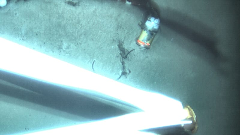
At about 1 a.m. EDT on Tuesday, the team aboard the research vessel Atlantis located the El Faro’s mast where the VDR was mounted. After examining numerous images provided by undersea search equipment, the team positively identified the VDR. (Courtesy of NTSB)
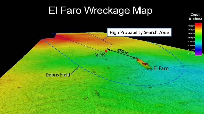
The team created high resolution maps of the seafloor, and ultimately the VDR was located in a search zone designated as “high probability” during NTSB’s first mission last fall. (Courtesy of NTSB and WHOI)
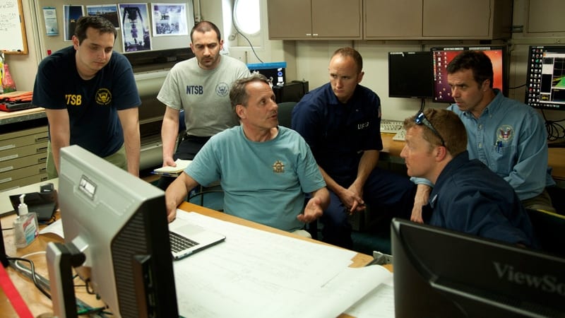
NTSB and U.S. Coast Guard investigators aboard Atlantis conferring with WHOI engineer Andy Bowen, director of the National Deep Submergence Facility. (Photo by Daniel Cojanu, Woods Hole Oceanographic Institution)
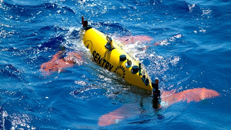
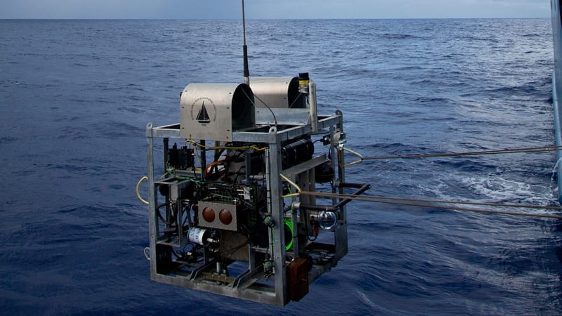
The autonomous underwater vehicle (AUV) Sentry, a one-of-a-kind vehicle designed and built by WHOI with funding from the National Science Foundation, was used to create high resolution maps and other imagery of the wreck site. (Photo by Daniel Cojanu, Woods Hole Oceanographic Institution)
The Alvin Observation Vehicle, built for use with the Alvin submersible and adapted for use on the NTSB mission, collected video imagery of the wreck site. (Photo by Daniel Cojanu, Woods Hole Oceanographic Institution)