More than two-thirds of Earth’s crust is created along seafloor spreading ridges, yet scientists rarely have a chance to observe the process is action. An event along the East Pacific Rise in 2006 provided researchers with a rare opportunity to observe what happens in the immediate aftermath of an eruption. The team used multibeam sonar to compile this topographic map of a portion of the ridge where the eruptions occurred. The black line shows the extent of the eruption — new lava flow stretched more than 18 km (11 miles) long and up to 3 km wide.
(Image courtesy of Adam Soule, Woods Hole Oceanographic Institution)
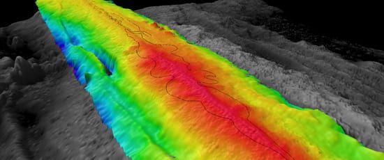
Image and Visual Licensing
WHOI copyright digital assets (stills and video) on this website can be licensed for non-commercial use upon request and approval. Please submit your request via our Media Request Form.
For assistance or accessibility accommodations, call (508) 289-2647.