The research vessel Crawford is tied up at the WHOI pier with the wing of a P5 Marlin (P5M) seaplane strapped to its side in 1960. “An attempt was made to improve the measurement of bottom slopes at right angles to the ship’s path by placing a second transducer at some distance from the hull,” WHOI scientists wrote in the Institution’s annual report. “To do this, a P5M seaplane wing was hinged to the side of the ship as a 45-foot outrigger. Tests were carried out in the harbor on the Asterias, in Vineyard Sound on the Crawford, and on the high seas on a destroyer. An initial evaluation of this unusual arrangement indicates that it may provide a technique to determine the slope of the bottom topography on a single traverse of an area.”
(Photo by Allyn Vine, Woods Hole Oceanographic Institution)
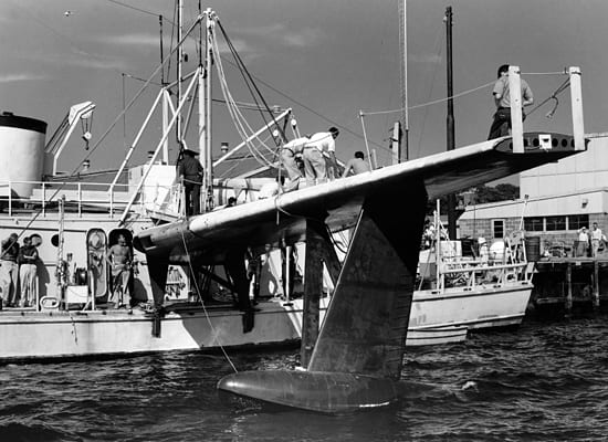
Image and Visual Licensing
WHOI copyright digital assets (stills and video) on this website can be licensed for non-commercial use upon request and approval. Please submit your request via our Media Request Form.
For assistance or accessibility accommodations, call (508) 289-2647.