Members of the WHOI Upper Oceans Processes Group aboard the NOAA ship Ronald H. Brown drop the anchor to deploy a surface buoy in a long-term study on air-sea interactions in the eastern tropical Pacific Ocean. The STRATUS project began in 2000 to better understand the role of persistent stratus clouds west of Peru and Chile and to investigate why climate models show errors in sea surface temperature in this region. The buoy is equipped with instruments that measure air temperature, humidity, wind speeds, and precipitation, and sensors that monitor ocean conditions from the surface to the bottom. The mooring provides real-time data to scientists on shore. (Photo by Ray Graham, Woods Hole Oceanographic Institution)

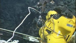


Image and Visual Licensing
WHOI copyright digital assets (stills and video) contained on this website can be licensed for non-commercial use upon request and approval. Please contact WHOI Digital Assets at images@whoi.edu or (508) 289-2647.