Discovering Hydrothermal Vents
Click to enlarge »
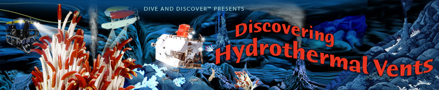
Map showing the tectonic plates in the eastern Pacific Ocean and location of the Galápagos Rift, the spreading ridge that separates the Nazca and Cocos plates. The red star shows the location of the site where hydrothermal vents were first discovered. The Southtow Expedition, on board Scripps Institution of Oceanography's R/V Thomas Washington in 1972, found clues leading to the discovery of hydrothermal vents at the Galápagos Rift. (Photo courtesy of Scripps Institution of Oceanography)
Click to enlarge »
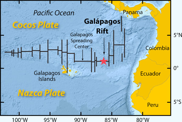
Scientists prepare to lower a heat-flow probe to the seafloor from the fantail of R/V Thomas Washington in 1972. The probe allows scientists to calculate heat flowing through seafloor sediments. (Photo courtesy of Scripps Institution of Oceanography)
Click to enlarge»
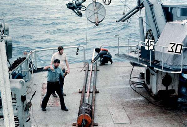
The Deep-Tow geophysical instrument package of Scripps’ Marine Physical Laboratory is equipped with precision sonar, cameras, and geophysical sensors that transmit data back to the ship via a cable. (Photo courtesy of Scripps Institution of Oceanography)
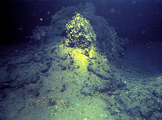
Click to enlarge »
The Southtow expedition found intriguing mineral-encrusted mounds sticking out of seafloor sediments. The mounds, like this one photographed on the 1977 Galápagos expedition, are formed by hydrothermal venting. (Photo by David L. Williams, USGS)
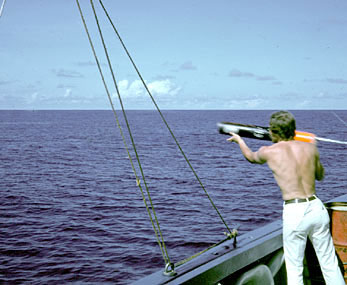
Click to enlarge »
Mark Legg, then a graduate student on the Southtow expedition, throws a sonobuoy overboard to detect micro-earthquakes at the seafloor. (Photo courtesy of Ken Macdonald, UCSB)
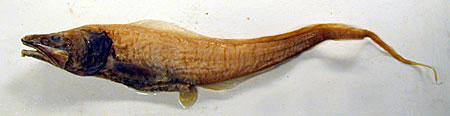
Click to enlarge »
Scientists on Southtow analyzed dead bottom-dwelling fish that they found floating on the sea surface. This one is a cusk eel (Porogadus sp.) and is 41.5 cm (about 17 inches) long. Fish like this were found in an area where scientists had detected a swarm of seafloor micro-earthquakes (and where hydrothermal vents were discovered five years later). In retrospect, the scientists concluded that the earthquake activity indicated a seafloor eruption, and the fish were killed by a powerful force that ruptured their swim bladders. (Photo by Philip Hastings, Scripps Institution of Oceanography)
With many early clues piling up to suggest that hydrothermal vents existed, scientists grew more eager to find one. Seagoing expeditions are difficult and expensive, so scientists had to zero in on a place where they thought they would have the best chances of finding vents. Of all the mid-ocean ridges in the world, which was the best place to look for vents?
Aside from actually going down to the seafloor to witness vents with their own eyes, the best way for scientists to find vents was to lower instruments to the ocean bottom to detect hot water or measure heat flowing in seafloor sediments. They needed an active volcanic ridge where they could insert their temperature probes into the seafloor. The probes wouldn’t go into hard lava, so they looked for a location near a ridge crest where the seafloor was covered by a thick blanket of softer sediments.
The Galápagos Rift seafloor had the right characteristics. Scientists at the Scripps Institution of Oceanography in La Jolla, California knew the area relatively well. Three Scripps research cruises in 1966, 1969 and 1970 collected heat-flow measurements at the Galápagos Rift, as well as temperatures of ocean-bottom waters. The measurements —analyzed by Scripps scientists John Sclater and Kim Klitgord—showed some evidence that hydrothermal venting was occurring at the Galápagos Rift.
The trail began in 1972 when scientists returned to the Galápagos Rift aboard Scripps’ R/V Thomas Washington. The expedition, called Southtow, was part of the International Decade of Ocean Exploration (IDOE). All the research cruises that led to the discovery of hydrothermal vents were funded by the IDOE.
Scientists on the Southtow expedition detected several signs of hydrothermal circulation in seafloor crust, including:
Scripps scientists and engineers led by Fred Spiess had built a deep-sea sonar and camera system called Deep-Tow. They were largely funded by the U.S. Navy, which wanted to develop equipment that could be rushed to sea to conduct searches on the seafloor. The Navy was motivated by the tragic loss in 1963 of the nuclear submarine Thresher, which sank along with its 127-member crew in 2,500 meters (8,250 feet) of water and could not be found quickly.
Deep-Tow also proved to be a very useful tool for scientific investigations. It was one of the first deep-submergence vehicles used by civilian scientists, and it collected data that led to many important discoveries. Deep-Tow is a big metal “fish” that is towed 10-100 meters (32 to 328 feet) above the seafloor on a long cable attached to a surface ship. The “fish” is packed with instruments, including underwater cameras, magnetometers, and sonars. The cable transmits data back to scientists on board the ship.
On the Southtow expedition, Deep-Tow’s camera found curious, roughly circular mounds sticking out of seafloor sediments about 18 to 36 kilometers (10 to 20 miles) south of the Galápagos Rift’s volcanic valley, near latitude 86°W. The mounds were 4.5 to 23 meters (15 to 75 feet) high and 18 to 45 meters (60 to 150 feet) in diameter. Many were crusted with minerals. Their shape and composition indicated that they were deposits formed by hot, mineral-rich fluids circulating in top layers of the ocean crust.
Using Deep-Tow, Southtow scientists measured water temperatures just above the seafloor and found they were a few tenths of a degree higher than normal seawater. This was slight but important evidence of hydrothermal activity.
The measurements of the heat flowing in seafloor sediments showed a curious pattern—the heat flow was higher in some areas and cooler in others. To explain this, David Williams and Richard Von Herzen of Woods Hole Oceanographic Institution theorized that hot fluids were rising out of the high heat-flow areas and cold seawater was sinking down into the low heat-flow areas. This pattern of circulating hot and cold fluids is called hydrothermal circulation—from the Greek words hydros (water) and thermos (heat).
During Southtow, scientists also used instruments called sonobuoys. These devices were developed during World War II to listen for submarines, but they were sensitive enough to detect earthquakes beneath the seafloor.
Using sonobuoys, Ken Macdonald, then a Woods Hole graduate student and now a professor at the University of California, Santa Barbara, detected bursts of small seafloor earthquakes over several days—sometimes as many as 80 per hour. These micro-earthquakes seemed to be occurring in the same area where bottom-water temperatures were slightly higher.
Then Macdonald saw something he had never seen before—or since. Floating on the surface were lots of dead fish. They were a kind of fish that only lived at great depths near the seafloor.
Soon, all these clues would fall into place. The micro-quakes were creating seafloor cracks that set the stage for hydrothermal circulation. In the same location where Macdonald detected the micro-quakes, scientists five years later would discover a lush community of seafloor life that they would call the “Garden of Eden.”
Ken Macdonald from the
University of California, Santa Barbara discusses the 1972 Deep-Tow cruise.
[ Back to Timeline ] [ Go to next section: 1974 - Project FAMOUS ]
![]() Terms of Use · About us · Contact Us · Privacy · Sitemap
Terms of Use · About us · Contact Us · Privacy · Sitemap
Copyright Woods Hole Oceanographic Institution · Dive and Discover™ is a registered trademark of the Woods Hole Oceanographic Institution
With funding from the National Science Foundation, NOAA's Ocean Explorer Program, the National Marine Sanctuary Foundation, and WHOI's Deep Ocean Exploration Institute