|
|
The
Martha's Vineyard Coastal Observatory (MVCO)  The MVCO is a research observatory located at South Beach and extending
into the ocean about a mile off the south shore of Martha's Vineyard.
It provides real-time and archived coastal oceanographic and meteorological
data for researchers, students, and the general public. Together with
other observatories located along the eastern coast from Maine to
Southern Florida, researchers are developing a more accurate, overall
view of meteorological and coastal processes occurring under a variety
of conditions.
The MVCO is a research observatory located at South Beach and extending
into the ocean about a mile off the south shore of Martha's Vineyard.
It provides real-time and archived coastal oceanographic and meteorological
data for researchers, students, and the general public. Together with
other observatories located along the eastern coast from Maine to
Southern Florida, researchers are developing a more accurate, overall
view of meteorological and coastal processes occurring under a variety
of conditions. |
|
|
|
|
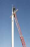
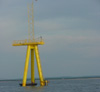
Air-Sea
Interaction Tower (ASIT)
The Air-Sea Interaction Tower (ASIT) is located in 15 meters of water
offshore of the MVCO. The objective of the ASIT is to investigate
ocean processes including air-sea interaction, ocean mixing, gas exchange,
bio-optics, and sediment transport. ASIT data is compared with data
collected from the shore-based MVCO. |
|
|
|
|
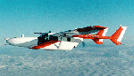
CIRPAS
Pelican Flights
The Pelican aircraft is investigating boundary layer structure for
CBLAST investigations by mapping out variability in momentum, heat,
moisture, and radiative fluxes. |
|
|
|
|
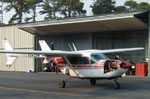
Aircraft
IR Remote Sensing
Airborne measurements of sea surface temperature variability using
infrared (IR) imagery were taken by this Cessna Skymaster operated
by Ambroult Aviation based of Chatham, MA.
|
|
|
|
|
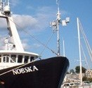
Nobska
Drifter Deployments
Preliminary drifter and cruise tracks generated by WHOI/MIT Joint
Program student Tom Farrar from data collected during the intensive
operating period. |
|
|
|
|
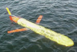
Slocum
Glider
These autonomous gliding vehicles are used to characterize the three-dimensional,
time-dependent structure of the shelfbreak front in the Mid-Atlantic
Bight, while simultaneously measuring physical and optical properties
across the width of the continental shelf. |
|
|
|
|
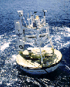
ASIMET
Buoy Array
The Upper Ocean Processes Group at WHOI deployed an array of buoys
and moorings in the ocean south of Martha's Vineyard to record data
including temperature, salinity, pressure, and current speed and direction.
The goal of this CBLAST component is to observe and better understand
the temporal and spatial variability of the upper ocean by investigating
the processes responsible for the exchange of mass, momentum and heat
between the ocean and the atmosphere under low wind conditions. |
|
|
|
|
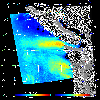
Satellite
Remote Sensing Mapping
of mesoscale and submesoscale wind fields using synthetic aperture
radar. |
|
|
|
|
COAMPS
Atmospheric Model
The Coupled Ocean-Atmosphere Mesoscale Prediction System (COAMPS)
is used as a tool for all testing and evaluation of newly developed
surface flux parameterizations. |
|
|
|
|
The
Regional Ocean Modeling System (ROMS)
The Regional Ocean Model System (ROMS) is a free-surface, hydrostatic,
primitive equation ocean model that uses stretched, terrain-following
coordinates in the vertical and orthogonal curvilinear coordinates
in the horizontal. Using the coupled ROMS/COAMPS model, ocean conditions
in the environs of the CBLAST-Low observational area are forecast.
|
|
|
|
|
|
|
|
|
|
|
|
|
|
|
|