Please note: You are viewing
the unstyled version of this website. Either your browser does not support CSS
(cascading style sheets) or it has been disabled. Skip
navigation.

 Mapping and Characterizing an Underwater Plume
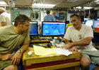
Deepwater Horizon, 2010 Principal Investigator: Rich Camilli WHOI scientists deployed the autonomous underwater vehicle (AUV) Sentry equipped with a compact, underwater mass spectrometer to identify and map the chemical plume spreading from the blown-out oil well. The techniques they used were developed at WHOI to find hydrothermal vents and underwater volcanoes. 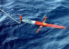 Mapping Gulf Currents
Deepwater Horizon, 2010 Principal Investigator: Breck Owens In the weeks after the Gulf oil spill started, WHOI scientists and their colleagues deployed an autonomous underwater vehicle called a Spray glider to map currents in the Gulf of Mexico from June to August. These measurements helped predict the spread of the oil at and beneath the surface and to alleviate fears that the oil would spread far beyond the Gulf. 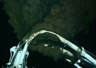 Calculating Flow Rate
Deepwater Horizon, 2010 Principal Investigators: Rich Camilli, Andy Bowen In the early weeks after the explosion of the Deepwater Horizon drill rig, estimates of how much oil was pouring into the Gulf varied widely. A reliable figure was crucial to helping everyone involved in battling the spill understand what they were up against. Last updated: July 28, 2014 | |||||||||||
Copyright ©2007 Woods Hole Oceanographic Institution, All Rights Reserved, Privacy Policy. | |||||||||||