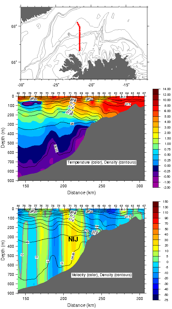

September 10, 2011Scientists seek to understand how the natural world works. Therefore, that we live in the world seems reason enough to look over their shoulders as they seek to understand its ways and means. I like that idea, though admittedly it’s a bit simplistic. There are a lot of shoulders to look over. Nature’s systems on land and in the air and ocean are dizzyingly complex and multiple, full of cycles, rich in oscillations, feedbacks, and variations across all timescales. And so in today’s science there is no such thing as a professional generalist. Even a specialist can’t know everything there is to know about his/her specialty in a lifetime. Take oceanography, itself a scientific specialization, within which there are subspecialties—chemical, biological, geological, and physical. Physical oceanographers, such as Bob and Kjetil, for instance, are concerned with the water itself, its movement. They care about the nature of the seabed only insofar as bathymetry tends to steer their currents. A geological oceanographer, however, would just as soon all that pesky water go away; it’s an impediment to understanding the geology beneath it. On this cruise, we have occasion, unique in my experience, It’s esoteric to be sure, as it must be because of the degree of specialization required to analyze ocean dynamics, but it’s not impenetrable to the rest of us. Bob just passed to me a revealing graphic depiction of the return data from the latest CTD section. Topmost of the three panels shows a map of the Denmark Strait, the present CTD line marked in red. The middle panel shows the temperature/salinity profile. The third panel, showing the velocity measurements from ADCP data, is perhaps the clearest. See that yellow swath running down the middle of the picture stretching from the surface to the bottom at 700 meters. That’s the North Icelandic Jet, exactly where it’s supposed to be. This is as close to real-time oceanography as it gets. If Bob and Kjetil find the NIJ where it’s supposed to be, and do not find it where it’s not supposed to be, then their hypothesis will be affirmed. That remains to be seen, but this is a good time to look at the hypothesis itself and the process by which it came to be.
First, let’s state the hypothesis. The NIJ is formed in the waters on the north slope of Iceland—it is not a current that flows from somewhere else and arrives at the north coast of Iceland. From there and only there, the NIJ flows into the Denmark Strait accounting for half of the water that overtops the shallow sill in the strait and spills into the much deeper North Atlantic. Or to put it differently: The NIJ is a significant part of the headwaters of the return flow that balances the northward flow into the Nordic Seas, the Meridional Overturning Circulation. That balance also serves to moderate our climate by distributing heat, The data from the 2008 cruise categorically verified the existence of the NIJ, and that’s all. Neither Bob and Kjetil, nor the Icelanders who originally discovered it knew how it came to be or why it was there. So Bob plopped the data down on Michael Spall’s desk and said essentially, “How could this be?” Spall, Bob’s longtime collaborator, is an ocean modeler. Using supercomputers and higher math and a modicum of creativity, modelers create, well, a model of ocean dynamics. Modelers are a different breed of cat from observational oceanographers. (Bob tells me that when he invited Spall on this cruise, Spall replied, “What would I do on a ship?”) I can’t even pretend to understand how modelers do their work, except to say that they try numerically to replicate the basic laws of physics as they act on water. They can feed into the computer a simple set of parameters or a lot of detailed parameters including but not limited to hydrography, bottom topography, and the position of dry landmasses, depending on whether they mean to produce a “simple” or a “realistic” model. They can put Iceland in the picture, for instance, watch how the water behaves, then take it out and compare the difference in behavior. Spall made a simple model, basic topography, no realistic landmasses, because he intended it to be simple in order to focus directly on the question at hand. So let’s skip to the picture. It included a current we’ve not yet mentioned, because no one thought it was particularly important: the North Icelandic Irminger Current. For much-needed simplicity’s sake, let’s call it the Irminger Current (IC). The Irminger Current is a branch of the North Atlantic Current delivering those many Sverdrups of Gulf Stream-origin water into the Nordic Seas. The IC diverges from the main flow south of Iceland and makes its way on the surface northward through the Denmark Strait hugging the Iceland side. It then flows over the north coast of Iceland at about one Sv., or one million cubic meters per second. Its existence was no mystery, but no one paid it much heed, because until the North Icelandic Jet came to the fore, no one thought it mattered. But in Spall’s model, considered in conjunction with the NIJ, it assumed new significance. On the north coast, the IC plays out, devolving into eddies (swirls of water like those you see in bathtub drains, only bigger) that spin lazily out into the Iceland Sea. There they become densified as they relinquish their warmth to the cold arctic air and slip beneath the surface. Okay, hoping that’s clear so far, I’m going to skirt the oceanographic technicalities—they get pretty thorny and hard to explain without introducing a welter of principles basic to the science, but far from basic to the rest of us. Suffice it to say that what happens is a miniature version of the hemispheric process we’ve already discussed: If a quantity of warm water goes north, then an equal quantity of cold water must go south. Nature insists. Thus the water that becomes the North Icelandic Jet, “replaces” that in the Irminger Current. Therefore, according to Spall’s model, there could be no North Icelandic Jet without the Irminger Current. There it is, the hypothesis. It’s a particular piece of scientific logic resulting from collaboration between two kinds of oceanographers, the sea-going kind and the shoreside kind—and the cooperation of technicians, the people aboard this ship and an Icelandic ship. That’s how ocean science works and knowledge progresses. Yeah, but what if it’s wrong? Bob is quick to say it might be. Well, then it’s back to the drawing board. The existence of the NIJ is not hypothetical. It’s real. If it is not formed according to logic stated above, then it comes from somewhere else, the north maybe or the east. What matters is that it flows into and out of the Denmark Strait. There’s no question about that. My money, however, is on these guys and their hypothesis. (Bob just warned me, however, to keep my money in my pocket.) Last updated: December 27, 2011 | |||||||||||
Copyright ©2007 Woods Hole Oceanographic Institution, All Rights Reserved, Privacy Policy. | |||||||||||