|
|
|
|
| Science - Historical data
The following data is presented as a historical
framework for the experiment. GLOBEC drifter data shows how several
drifters moved through the Cape Hatteras region. Mooring data from
the OMP shows how the currents change over spring and late summer
time periods. In addition, marine mammal survey data is available
for previous years.
| GLOBEC
drifter data (1995-2000), compliments of R. Limeburner, R. C.
Beardsley, and K. Brink, WHOI |
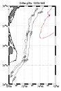 |
Animated GIF movies
Satellite-tracked drifters with holey sock
drogues centered at 10, 15, and 40m depths were deployed over
Georges Bank during 1995-1999 in support of U.S. GLOBEC/Georges
Bank Program. The following plots are from drifters that became
entrained in the shelfbreak front and traveled south along the
length of the Middle Atlantic Bight. These movies show the fate
of selected drifters that pass through the Cape Hatteras region.
Select a drifter from the pulldwn menu below and click "Go"
to display an animated GIF of the drifter track. The movie will
repeat automatically.
These jpeg plots show the final frame of the above movies.
|
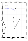
Mile
106 drifter data, compliments of J. Churchill, WHOI
Thanks to Paul Dragos, Batelle |
|
Animated GIF movies
A second drifter data set was from a study
of transport from the vicinity of the 106 mile dump site used
by the City of New York. The drifters were all launched at intervals
over the dump site, on the continental slope, and many of them
passed near Cape Hatteras. Select a drifter from the pulldwn
menu below and click "Go" to display an animated GIF of the
drifter track. The movie will repeat automatically.
|
Ocean Margins Project (OMP) mooring data (1996), compliments of J. Churchill, WHOI
Thanks to Charlie Flagg, SUNY-Stony Brook |
 |
Animated GIF movies
The OMP project, funded by the Department of Energy, studied the waters of the
Cape Hatteras region using an array of moored instruments. These movies
show the low-passed (1 day mean for OMPA, 2 day mean for OMPB) currents
at seven moorings along the 70m isobath. The surface wind from
National Data Buoy Center buoy # 44014 is shown concurrently
in blue. Note the difference in scale between the current and
wind vectors.
|
| Links
to OBIS-SEAMAP marine mammal survey data |
 |
SEFSC Southeast Atlantic surveys, 1992
SEFSC Southeast Atlantic surveys, 1998
SEFSC Southeast Atlantic surveys, 1999
SEFSC Mid-Atlantic Bottlenose Dolphin Survey, 1995 No.1
SEFSC Mid-Atlantic Bottlenose Dolphin Survey, 1995 No.2
SEFSC Mid-Atlantic Bottlenose Dolphin Survey, 1995 No.3
UNCW Marine Mammal Surveys, Southeastern US 1998-1999
UNCW Marine Mammal Surveys, Southeastern US 2001
UNCW Marine Mammal Surveys, Southeastern US 2002
|
|
|
|