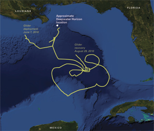
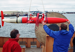
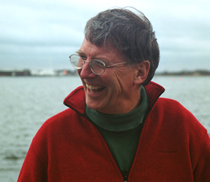
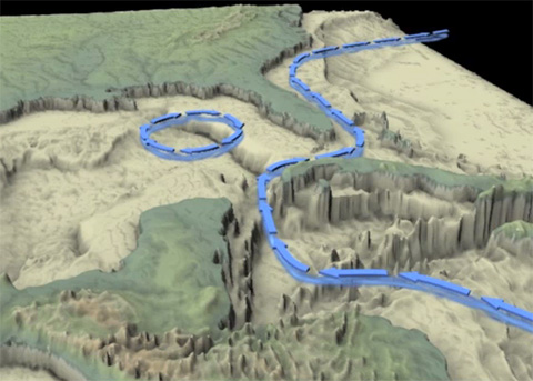
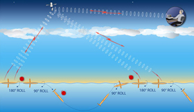
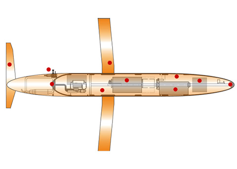
In the initial days of the Deepwater Horizon disaster, a spotlight shone on a little-known watery cog in the ocean’s circulatory machinery: the Loop Current in the Gulf of Mexico. Where that chaotic current was located and how it was moving in the spring of 2010 would determine whether oil would spread widely beyond the Gulf, causing much more damage and demanding even greater emergency responses. Breck Owens, a physical oceanographer at Woods Hole Oceanographic Institution (WHOI), had a roving robot able and ready to answer that crucial question. “One of the concerns was that the oil spill was going to get into the Loop Current, which is a big, warm current that comes from the Caribbean between the Yucatán Peninsula and Cuba into the Gulf of Mexico,” Owens said. “It sometimes loops up relatively close to Louisiana, and then travels back down past Key West, through the Florida Straits, and feeds the Gulf Stream. Under the worst-case scenario, if the Loop Current had been near the Deepwater Horizon site, it could have brought oil all the way past Key West, all the way up the east coast of Florida, all the way up to Cape Hatteras, and then spread it out into the North Atlantic.” (See animation on right.) The critical word in that description is “sometimes.” Three or four times a year, the loop in the Loop Current narrows at its southern end and pinches off a swirling circle of water called an eddy, which drifts westward and eventually bumps into the coast of Texas. When that happens, the Loop Current temporarily loses its loop. It flows more directly from west of Cuba to the Florida Straits, bypassing the central and northern parts of the Gulf. Chaos and currentsLoop Current eddies form “in a random, chaotic way,” Owens said. “It’s like letting go of a garden hose: You know it’s going to flop around, but at any given time, you can’t predict exactly where it’s going to be. The Loop Current is part of the turbulent ocean. We know eddies are going to form, we know roughly how often it happens, but exactly when it’s going to happen is something we have a great deal of difficulty predicting.” To track the ocean’s ever-changing currents, scientists at WHOI and Scripps Institution of Oceanography developed the Spray glider, a 6-foot, 110-pound, torpedo-shaped underwater vehicle. It can remain at sea for months, collecting measurements and periodically rising to the surface to transmit data back to scientists on shore. (See interactive on right). The gliders were based on instrumented floats developed in the 1990s. “We realized that if they grew wings, we could then control them,” Owens said. “They could fly through the water, whereas the floats only traveled with the water.” Via the same system that sent data to shore, the scientists could send commands to the gliders. “We could control the gliders, tell them where to go, and keep them in a region for a long time,” he said. In its first long-distance test, in 2004, Owens remotely piloted a Spray glider over 50 days, from Martha’s Vineyard to Bermuda, proving it could be steered across one of the ocean’s strongest currents, the Gulf Stream. Glider pilotEven before the big spill, Owens was keenly interested in investigating the Loop Current. The powerful current has strong impacts on navigation and infrastructure (such as oil rigs) in the Gulf, as well as on hurricanes. During the summer of 2005, for example, the Loop Current was in a position that brought deep pools of warm water into the Gulf. Hurricanes Katrina and Rita both passed over the warm waters of the Loop Current, absorbing more energy that allowed them to intensify. For these reasons, BP, owner of the Deepwater Horizon oil rig, spends considerable sums monitoring the Loop Current. In 2008, Owens undertook a two-year project funded by BP to demonstrate that gliders could provide an efficient and effective way to keep track of the current’s meanderings. So it was not surprising that shortly after the oil rig exploded on April 20, 2010, a glider was in the vicinity. Technicians from Scripps and WHOI equipped it with sensors to measure seawater temperature and salinity, current directions and velocities, and reflections from particles in the water, such as oil. The glider was launched on June 7, and Owens remotely piloted it through the Gulf for three months. He also coordinated with researchers who subsequently launched and steered other gliders the Gulf. “People in the oceanographic community rallied to help in this disaster,” Owens said. “I'm incredibly proud of the job we did, basically volunteering in the beginning, trying whatever possible to make measurements to help provide information to better predict where the oil spill was going. It speaks well of our community, and our concern for the ocean.” A fortuitous eddyOwens checked on the glider several times a day when it surfaced. “You have to look at the data, try to decide what they mean, and give the glider new instructions,” he said. “It was a few hours a day, every day, for three months. You just worked it into your schedule. My wife told me several times that we'd already raised two children. Sometimes she didn't enjoy raising a fleet of gliders, another whole family that I've kind of taken on, to try to watch over.” In early June 2010, the Loop Current formed an eddy. It effectively acted as a whirling barrier, blocking spilled oil from reaching the current farther south and flowing through the Florida Straits. “I think we, as a country, were really lucky,” Owens said. “The East Coast got off the hook because Nature was kind.” But Nature and the Loop Current weren’t so obliging in 2005, when hurricanes Katrina and Rita devastated the Gulf. Owens sees the day when “gliders could be the basis for an ocean-observing system for oil spill monitoring, field operations, hurricane prediction, and navigation forecasts.” In winter, satellites can detect the warm Loop Current, which contrasts with cooler Gulf of Mexico waters. But as the shallow Gulf warms up in summer, satellites can't easily discern temperatures differences that a glider can. Part of the deployment and the preparation of the glider was funded by residual funds from a contract with BP and by a National Science Foundation RAPID grant. Owens was supported by the W. Van Alan Clark Jr. Chair at WHOI. Originally published: March 23, 2011 Last updated: August 14, 2013 | |||||||||||||||||||||||||||||||
Copyright ©2007 Woods Hole Oceanographic Institution, All Rights Reserved, Privacy Policy. | |||||||||||||||||||||||||||||||