Coupled
Boundary Layers
Air-Sea Transfer
(CBLAST)
Low Wind Component
CBLAST-Low
Data
The
Martha's Vineyard Coastal Observatory (MVCO)
Real-time and archived coastal oceanographic and meteorological data
include wind speed, relative humidity, wave height, and current direction.
Together with other observatories located along the east coast from
Maine to Southern Florida, researchers are using this south-facing
location on Martha's Vineyard to help develop a more accurate, overall
view of meteorological and coastal processes occurring under a variety
of conditions.
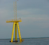
Air-Sea
Interaction Tower (ASIT)
The Air-Sea Interaction Tower (ASIT) is located in 15 meters of water
offshore of the MVCO. The objective of the ASIT is to investigate
ocean processes including the transport of carbon dioxide and other
gases between the ocean and air, ocean mixing, bio-optics, and sediment
transport. ASIT data is compared with data collected from the shore-based
MVCO. FTP
site for air-side ASIT data
Aircraft
IR Imagery
Flight plots on sea surface temperature variability using infrared
(IR) imagery.
NCAR Flight Plots
Data collected by National Center for Atmospheric Research (NCAR)
scientists involved in CBLAST experiments.
CBLAST
Mooring Arrays
Mooring arrays were deployed during all three field seasons of the
CBLAST program.