|
History
US Military Buildup of Thule and DEW Line (1950s-1960s)
With the advent of the Cold War, the
US military began to look at the northern regions as the front
line of defense against the USSR. During the war, the Allies
had established weather stations in Greenland and Canada, but
now the US wanted an air base that could be used to intercept
bomber attacks from northeast approaches to America, and as
a refueling point for long range bombers potentially directed
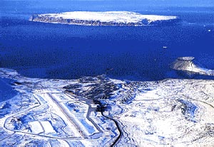
at the Soviet Union. Midway between Moscow and New York, Thule,
Greenland was selected as the site. The Thule region had been
inhabited by native Greenlanders for centuries, had served as
base for Robert Peary's North Pole expeditions, and was a trading
station and base for five scientific expeditions by Danish explorer
Knud Rasmussen between 1912 and 1924, besides being an Allied
weather station.
The Thule Air Base was constructed in total secrecy by the US
military under the code name 'Blue Jay' in 1951. An armada of
120 shipments, 12,000 men, and 300,000 tons of cargo arrived
in North Star Bay in July 1951, and construction immediately
began. Living on board the ships and working around the clock,
most of the airfield and base were built in only 60 days. Buildings
were constructed with refrigerator-like Clements panels, and
propped on pilings to prevent melting into the permafrost. During
its peak, it housed approximately 10,000 personnel. Now, less
than 1,000 men and women are stationed there.
Besides supporting military objectives, Thule Air Base has also
been used as the staging point for scientific ventures, most
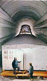
notably, the construction of Camp Century, an entire city for
85-200 residents carved 200 feet into the ice, 150 miles from
Thule. Camp Century was opened in 1959 and included a nuclear
reactor for heat and power. Research included studies of the
structural properties of snow, meteorological studies, and ice
coring by the US Army Cold Regions Research and Engineering
Laboratory (CRREL). The camp was closed in 1967.
In addition to the Thule Air Base,
the 1950s saw the establishment of the Distant Early Warning
(DEW) line of 63 radar and communication stations. Extending
3000 miles from Alaska to Baffin Island, roughly along the 69th
parallel, the radar stations provided overlapping coverage for
the detection of attack by bombers or missiles from the north.
Construction began in December 1954 and work was completed in
July 1957. Altogether 460,000 tons of material were moved by
air, sea, and land to build the stations. In 1985, the US and
Canada signed a treaty that began the upgrade and transition
to the North Warning System (NWS), which is operational today.
The official DEW line closing ceremony was held in 1993, and
the abandoned DEW line facilities are now the focus of a massive
cleanup effort by the Canadian government.
References:
On the web: Harris, Lynden T., The DEW Line Chronicles
On the web: Thule Air Base by Michael Salling
On the web: Thule History
Project SKIJUMP (1951-1952)
In order to develop a Flying Laboratory
technique similar to earlier Soviet activity and to study the
oceanography of the Arctic Ocean, the US Office of Naval Research
inaugurated Project SKIJUMP in the western basin in 1951. During
the 2-year project, Navy aircraft equipped with skis landed
on the Beaufort sea ice, and WHOI scientist Val Worthington
completed eight hydrographic stations in the previously unsampled
region. The station work consisted of setting up a hydro winch
inside a tent on the ice, which was kept warm using a hot air
blower, boring a hole in the ice, and lowering Nansen bottles
to depths as great as 3000 m. During the first year, it took
2-1/2 hours to hack through the sea-ice using chainsaws and
chisels; in 1952 using a gas-powered auger reduced this task
to 10 minutes. Despite the care to keep the samples and equipment
relatively warm, some measurements were spoiled by frozen water
samples froze and thermometer failures. In all, about 100 points
were acquired before the landing gear collapsed on one aircraft,
and it and the hydro winch had to be abandoned, which prematurely
ended the field program. However the results from this study
were notable in that they indicated the presence of the anticyclonic
surface circulation, which we now call the Beaufort Gyre, and
also suggested the existence of a submarine ridge separating
the deep water masses between the east and west Arctic, which
we now recognize as the Lomonosov Ridge.
Reference:
Worthington, L.V., Oceanographic results of Project Skijump
I and Skijump II in the Polar Sea, 1951-1952, EOS, Trans.
AGU, 34, 543-551, 1953.
 Previous Chapter
Next Chapter
Previous Chapter
Next Chapter

|