Research Interests
I am currently an Oceanographer Emeritus in the Physical Oceanography Department at the Woods Hole Oceanographic Institution with a wide range of research interests in the coastal ocean. Primarily the dynamics of the coastal ocean such as the general circulation, buoyancy and wind forcing, tidal rectification, sea ice annual cycles, mixing, LaGrangian (drifter) trajectories, circulation under Antarctic ice shelves, and global climate changes. More recent interests include predicting debris paths to locate lost commercial airplanes and ships on the sea floor, and the tragic effects of the European Union's policies of non-assistance to migrants at sea. I approach problems using numerical modeling, field work, observations, and new instrumentation.
Projects
 |
Federal Court Case involving an Offshore Recreational Boat Accident and Death
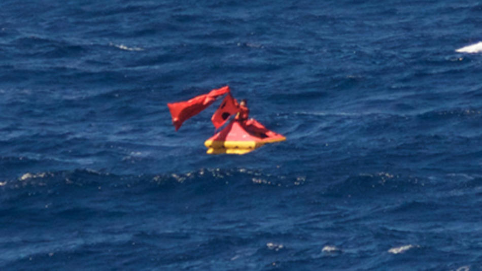
Ocean currents, surface waves, and winds during September 18-25, 2016 were used to estimate the path of a drifting life raft occupied by Nathan Carman near the shelf break region approximately 100 nautical miles (nm) south of Marthas Vineyard Island, MA. Carman was recovered on September 25, 2016 by the freighter ORIENT LUCKY. A Federal judge in Providence, RI ruled that Carman made improper and faulty repairs to his boat CHICKEN POX that contributed to its sinking on September 18 during a fishing trip with his mother, who disappeared at sea and is presumed dead.
Life Raft Path Report
Wired Story by Evan Lubovsky
|
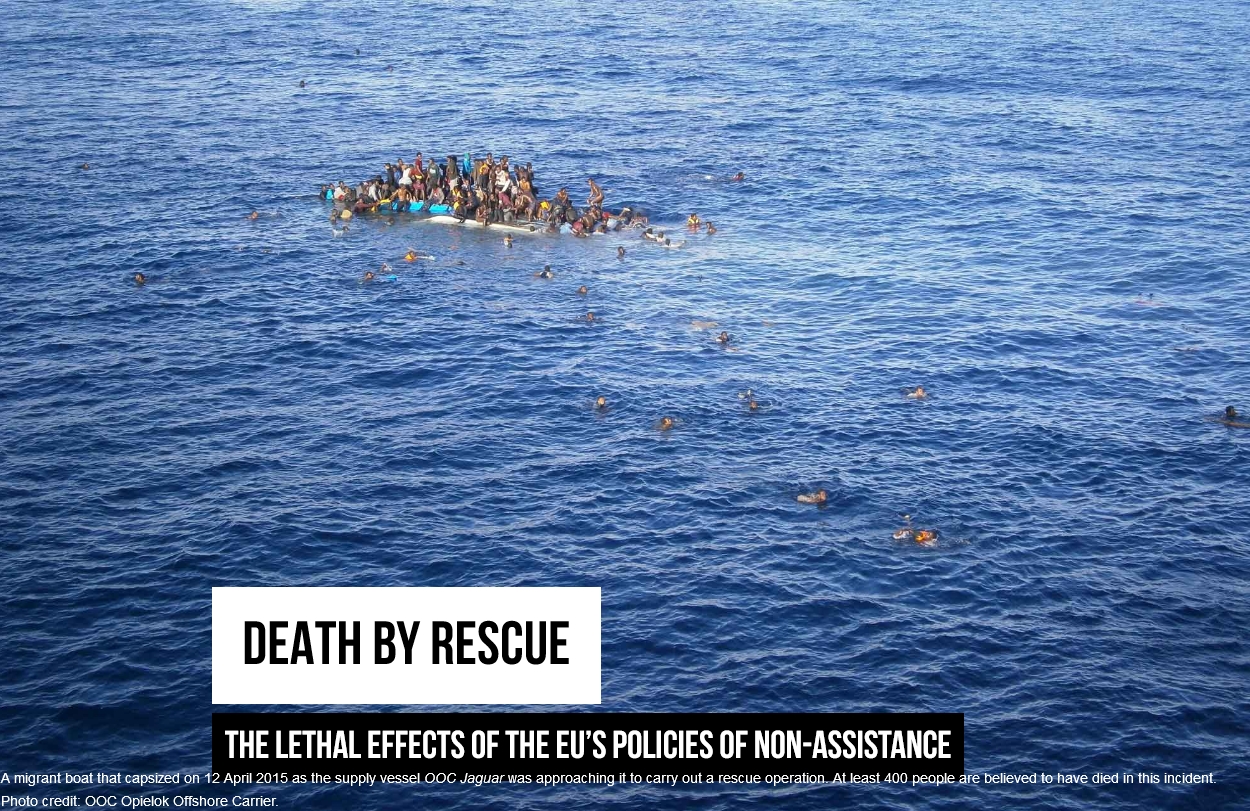 |
Death by Rescue
During April 2015 approximately 120 km north of Libya two fishing boats overloaded with migrants from Africa capsized in 2 separate incidents. It is believed more than 1200 migrants died in these two tragic accidents alone despite the presence of rescue boats near each capsized boat. Wind and wave conditions at the time of the accidents were calm, but the difficulty of the at-sea rescue operations and subsequent deaths of so many of the migrants was directly attributeable to the European Union's past policies of non-assistance to migrants at sea.
Death by Rescue
|
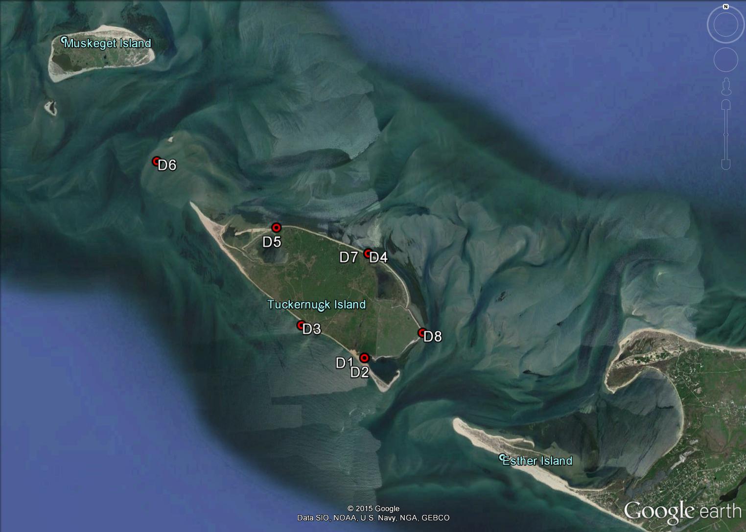 |
Tidal Variability in Sea level near Tuckernuck Island, Massachusetts
Tuckernuck Island is located along the Massachusetts coast between Nantucket and Marthas Vineyard Islands and is surrounded by shifting shallow, sand shoals. North of Tuckernuck is Nantucket Sound and south of Tuckernuck is the Atlantic Ocean. The coastline of Tuckernuck is constantly eroding or acreting due to winds, waves, and variations in sea level. Tidal elevations around Tuckernuck Island had not been measured prior to 2013, but local knowledge indicated the tide was greater and earlier on the south shore. Botttom pressure recorders were deployed at 8 locations around Tuckernuck Island during 2013.
Tidal Variability in Sea level near Tuckernuck island, MA
|
 |
Patagonia Montt Glacier Mooring
The Patagonian Ice fields, located in southern Chile and Argentina, are the largest temperate ice bodies in the Southern Hemisphere, and are thought to contribute significantly to sea level rise (SLR). However, little is known of the rate at which these glaciers are discharging freshwater to the ocean, or its variability. The Jorge Montt glacier, located in the Southern Patagonian Ice field, is an excellent case study of a tidewater glacier undergoing rapid retreat, and it provides relatively accessible conditions and reasonable size for conducting fieldwork throughout the year. The focus of the field work was to quantify the meltwater discharge of this systemand to examine the ocean circulation and hydrographic structure at tidal and subtidal time-scales in the vicinity of the glacier.
Patagonia Montt Glacier Mooring
|
 |
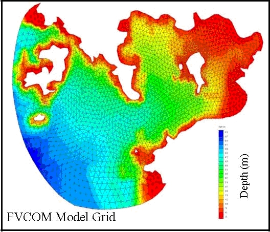
Air France 447
On June 1, 2009 Air France AF447 disappeared in the Equatorial Atlantic en route from Rio de Janeiro, Brazil to Paris, France. During June 6-19, 2009 debris from the aircraft was recovered floating in the equatorial ocean. Changsheng Chen UMass Dartmouth Smast) and I modeled the tracks of the debris field back to the time of the crash using FVCOM so that efforts can be made to locate the cockpit voice and data recorders and learn why this tragic accident occurred. Our methodology was to develop a nested high-resolution model of the region for June 2009, and then optimize the model by assimilating all available observations of near-surface currents. Different wind forcing was then used to track the surface debris backwards in time to estimate the location of the crash site.
Air France 447
FVCOM model estimate of the location of Air France 447
| 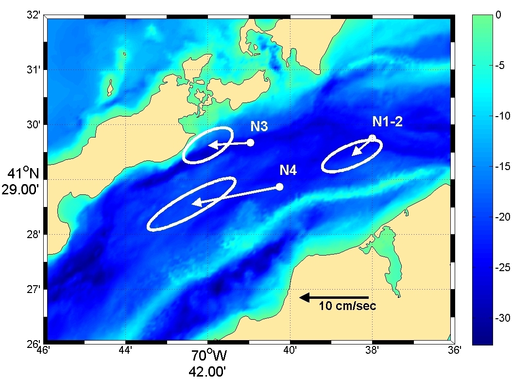 |
Nantucket Sound Circulation - Observations, Analysis and Model Development
Moored measurements of current, pressure, temperature and conductivity (salinity) were made on a bottom tripod located at a depth of 26m approximately half way between Nobska Point, Woods Hole and West Chop, Marthas Vineyard on four deployments during July 16, 2004 to November 22, 2006. The currents were dominated by strong semidiurnal tidal currents up to 200 cm/s. The maximum tidal current was in phase with the maximum tidal elevation indicating the local tide is characterized by a progressive wave. The mean flow was southwestward throughout the well mixed water column. The low-frequency current variability was dominated by the windstress. The moored data compared well with newly developed FVCOM model output (Chen et. al., 2007). These results are now being used to develop an operational coastal management model system for the New England Shelf (NES) with the focus on Nantucket Sound (NS) and Buzzard Bay (BB).
Nantucket Sound Circulation
|
 |
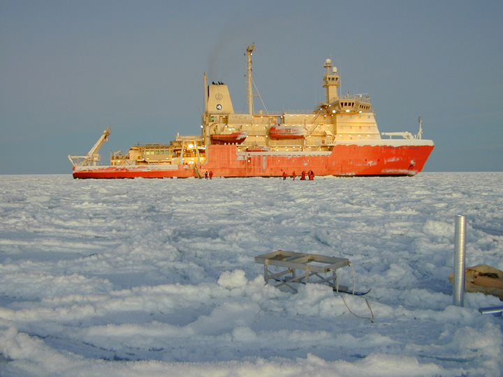
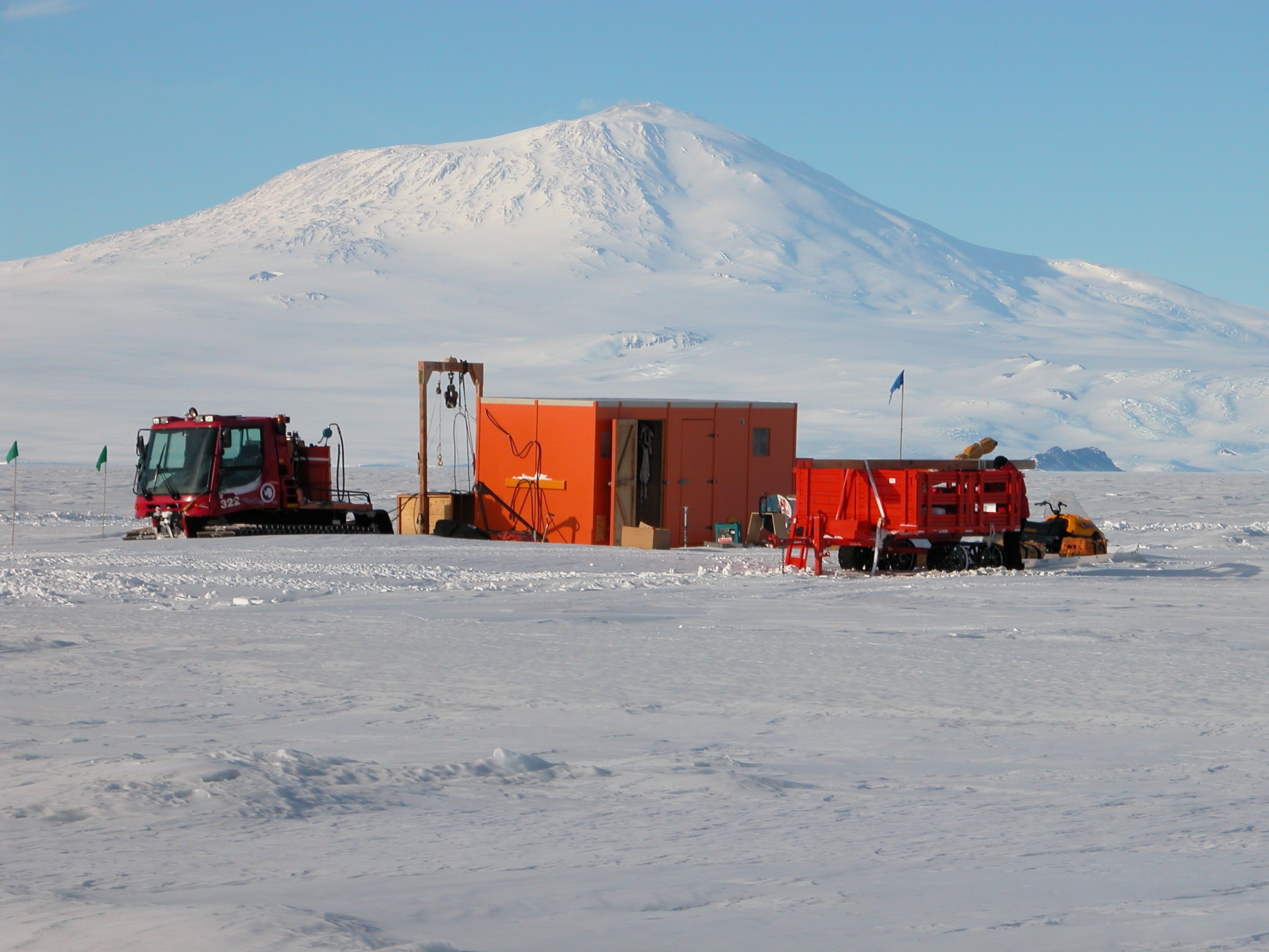
ANDRILL Coulman High Mooring 2010
We deployed a mooring in November 2010 for 14 months on the Ross Ice Shelf in Antarctica. The mooring was located at the Coulman High site 110 miles away from McMurdo Station. The purpose of the mooring was to characterize the currents so the ANDRILL program can design and deploy a bottom coring drill rig here in 2012. ANDRILL is an international program of geologists studying climate change and based at the University of Nebraska in Lincoln. At the Coulman High mooring site the Ross Ice Shelf is about 250m deep with a water column below the ice of 650m. The surface of the ice shelf is about 50m above sea level. A New Zealand group drilled a 25 cm hole through the ice and then the WHOI group suspended the mooring from the ice surface to 10m off the sea floor.
ANDRILL Coulman High Mooring
|
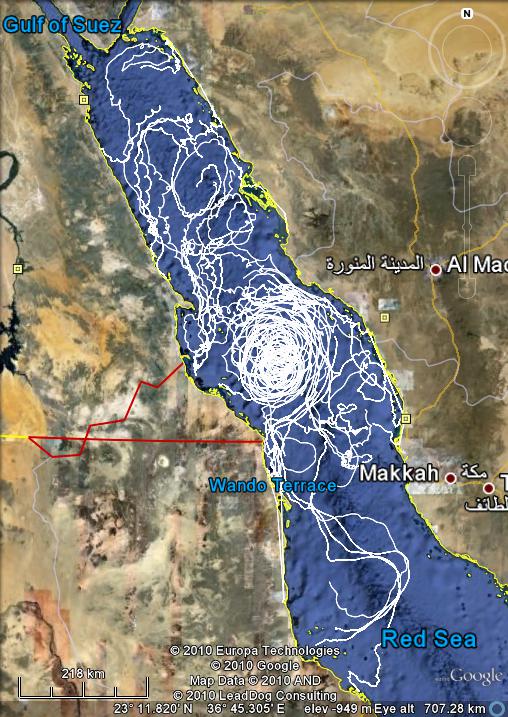 |
KAUST Red Sea Drifters
We deployed satellite-tracked surface drifters in the Red Sea during the semi-annual large-scale and
small-scale KAUST hydrographic cruises for three years 2008-2010 in order to investigate the
near-surface Lagrangian currents in the Red Sea. These drifter deployments will focus on the
small-scale KAUST coastal region, but drifters will also be deployed over the entire eastern Red
Sea. The research cruises will collect important hydrographic and biologic data on the Red Sea
ecosystem, but to date there have been very few direct measurements of currents
Red Sea Drifter
username drifter pw gps
|
 |
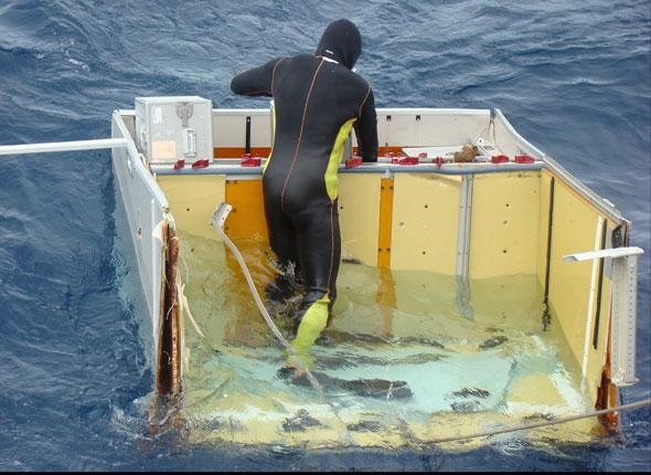
KAUST Red Sea Bottom Pressure Variability
We deployed an array of three bottom pressure/temperature/conductivity (PTC) instruments every 6 months at Jeddah (JP), Thuwal (TP) and Rabigh (RP) along the Saudi Arabian coast near the KAUST study site during 2009-2011. This PTC array accurately measured the regional tidal variability of the sea surface and characterize the low frequency along-shore and across-shore pressure, temperature and salinity gradients and their variability. The bottom pressure instruments measure total pressure (water pressure plus atmospheric surface
pressure) continuously with an accuracy of about 1 mm and will record an average pressure
approximately every 5 minutes.
Red Sea Bottom Pressure Variability
username pressure pw ptc
|
 |
Modeling the Liquid Jungle: Biological-Physical Interactions in Isla Canales de Tierra and nearby Bahia Honda Bay, Panama
We conducted seasonal hydrographic surveys (P, T, C(S), DO and fluorescence) in the waters surrounding Isla Canales de Tierra, Panama and apply a state-of-the-art hydrodynamic model, the Finite-Volume Coastal Ocean Model (FVCOM), to the region. The model will be used to gain a better understanding of the hydrodynamic processes and their potential impact on ecosystem dynamics in this region. The development of this tested hydrodynamic model is the first step towards our goal of building a coupled biological-physical model of the region.
Liquid Jungle Lab
|
 |
Palmer LTER Lagrangian Current Measurements
We deployed satellite-tracked near surface drifters during the annual austral summer Palmer Long Term Ecological Research (LTER) program January cruises during 2005-2007 in order to investigate the near-surface Lagrangian currents over the Western Antarctic Peninsula (WAP) shelf between 63 and 68 S.
Palmer LTER Lagrangian Current Measurements
|
 |
ANDRILL SMS Mooring 2006
A current meter mooring was deployed on October 25, 2006 through the frozen surface ice of the Ross Sea in support of the ANtarctic geologic DRILLing (ANDRILL) project by David Harwood (University of Nebraska), Richard Limeburner (Woods Hole Oceanographic Institution) and Peter Webb (Ohio State University). The mooring is located at the SMS site 77° 45.157 S and 165° 29.372 E, approximately 18 miles west northwest of McMurdo Station, Antarctica. The SMS mooring site is normally covered with seasonal sea ice, but at present the region has been permanently frozen for the past 10 years.
ANDRILL SMS Mooring
|
 |
Errata
In this section you can access my publications and CV. Revised January 1, 2022.
Education
CV [PDF document]
|
 | Support from the National Science Foundation, Smith Chair, Sea Grant and the Woods Hole Oceanographic Institution Ocean Life Institute is gratefully acknowledged. |  |
|