The
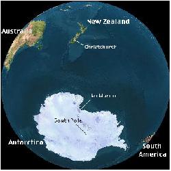
CORSACS cruise will begin from near Christchurch New Zealand and end at McMurdo
Station Antarctica. 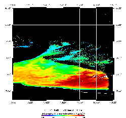
Satellite
image showing chlorophyll distribution in the Ross Sea from December 5th 2005. 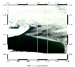
Satellite
image from December 5th 2005 showing opening of the polynya. 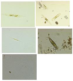
Microscope
image of pennate diatoms in the Ross Sea, image taken by the DiTullio Group. 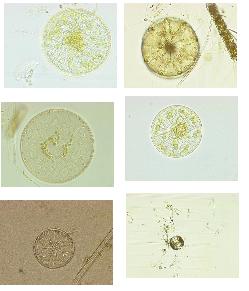
Microscope
images of centric diatoms from the Ross Sea, taken by the DiTullio Group. 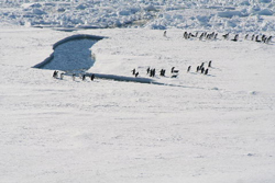
January
11: Adelie penguins arrive to investigate the humans. (Jack DiTullio) 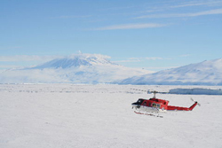
January
11: Supplies arrive for the ship via helocopter. (Jack DiTullio) 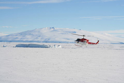
January
11: Another view of the resupply helocopter. (Jack DiTullio)

January
11: Supplies from the helocopter are placed on a platform that is then brought
up onto the ship with the ship's crane. (Jack DiTullio) 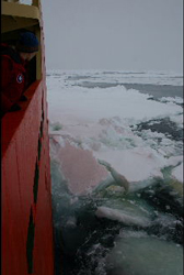
January
12: Ice being pushed out of the way by our ship the Icebreaker N.B. Palmer 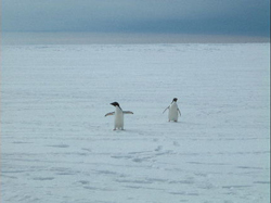
January
12: Two curious Adelie penguins approaching us.
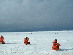
January
12: Members of the science party photographing more than a dozen Adelie penguins
moving by on their stomachs on the ice. Note the red line on the ice. Natty B.
crewmembers paint this line on the ice to indicate where the ice is thick enough
to be safe to walk on. 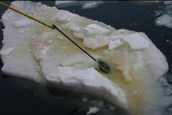
January
12: Sampling algae growing under the sea ice. 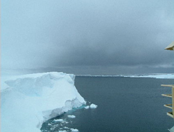
Historic
Bay of Whales (Mak Saito)
| CORSACS: Controls on Ross
Sea Algal Community Structure
2005: A Research Cruise to the Ross Sea to Study
What Controls the Phytoplankton DynamicsChief Scientist's Log Week
1 Southbound Days
3-5 - December 20 and 22, 2005 We are continuing our transit
south into the Ross Sea and have been fortunate to encounter extremely calm conditions
in the Southern Ocean. The major ocean current in these waters is called the Antarctic
Circumpolar Current (ACC) and it moves from west to east and is driven by the
strong westerly winds in this region. Luckily, the winds have only been 10-20
knots on our trip so far. As a result nobody onboard has been seasick. We have
begun having short science talks in the morning so that everyone becomes aware
of the work that is being done on the cruise. Yesterday, I gave a short science
talk on cruise objectives and Professor Walker Smith (Virginia Institute of Marine
Science) summarized the results of photosynthetic research from many previous
expeditions in the Ross Sea. He has been performing research in the Ross Sea since
1983. This morning Professors Dunbar (Stanford University) and Tortell (University
of British Columbia) discussed the carbon cycle. Their talks involved aspects
of chemistry, biology and physics. Professor Dunbar (who has been doing research
in the Ross Sea since 1982) talked about the chemistry of the carbonate system
in seawater and how efficient it is in buffering the water against changes in
pH. Professor Tortell (his first trip to Antarctica) talked more about the biology
of the system, especially with respect to carbon dioxide. One hypothesis we are
testing on this cruise is whether changes in carbon dioxide levels of the water
will affect the algal community structure. Both talks discussed changes in the
carbon cycle that occurred over glacial and interglacial periods over the last
400,000 years. During the last couple of days, scientists have been putting
instruments in the water to test their equipment. For instance, yesterday Dr.
Saito (Woods Hole Oceanographic Institute) put the trace metal rosette and water
sampling bottles in the water. Today we have completed two other important test
operations. The first is probably the most critical piece of equipment for any
oceanographic expedition. It is called the CTD rosette. CTD stands for conductivity,
temperature and depth. This rosette has many different instruments attached to
it. These include sensors that tell us the temperature, salinity, pressure, oxygen,
chlorophyll and particle concentration in the water. This rosette also has 24
ten liter bottles attached to it. We will collect water from different depths
in the ocean with these bottles. Today we collected water from 1000 meters depth.
The ocean here is about 4500 meters deep, that’s more than 2.5 miles deep.
Phytoplankton can only grow near the surface of the ocean though because sunlight
for photosynthesis only reaches down to about 150 meters. This fact means that
most of the ocean is a very dark place. The second piece of equipment we
tested today is vital to the success of our research cruise. It involves attaching
a pump tube to a vane (we call it a fish) and towing it through the water (we
call the instrument a towfish). Then we can pump trace metal clean sea water from
the ocean into our clean laboratory without the water making contact with the
outside air. It is important to not contaminate our water because one speck of
dust from the air would be enough to contaminate this water with iron. The Southern
Ocean has very little iron dissolved in the seawater and photosynthesis by phytoplankton
is limited by the amount of iron available. Dr. Sedwick (Bermuda Biological Station
for Research) is the principle investigator measuring iron concentrations on our
expedition. Another one of our major research goals involves studying the effects
of iron on phytoplankton photosynthesis and on its affect in changing the phytoplankton
community structure. Typically, when iron is added to seawater from the Southern
Ocean region diatoms are the major group of phytoplankton that bloom. But we will
test the hypothesis that high iron and low light levels will not cause diatoms
to bloom in the Ross Sea but rather a type of phytoplankton called Phaeocystis
antarctica. ------------------------------ Days
1-2 - December 18 and 19, 2005 We are now steaming south for
Antarctica. We left Lyttleton Harbor, New Zealand on Sunday December 18, 2005
at 1000 hrs. The last few days have been spent loading all of our scientific gear
and setting it up in the various laboratories and laboratory vans around the ship
(lab vans are usually 20 foot long steel shipping containers that have been retrofitted
inside to make them into laboratory spaces). New Zealand was beautiful and the
port of Lyttelton was one of the nicest ports we’ve seen, although we were
next to a ship unloading sulfur fertilizer by the ton yesterday, and there was
some concern about the potential for sulfur dust contaminating our scientific
instruments. Yesterday, we went through the ship’s safety overview
- getting into our survival suits (they are also called gumby suits) that are
designed to allow a person to avoid hypothermia (cold body temperature) when in
the water (see day 1-2 slide show for pictures). And we got to go inside the lifeboats
- the lifeboats on this ship are pretty amazing - they seem basically like a fiberglass
shell shielding the passengers from stormy seas. They have enough food and water
for 70 people for several weeks. Let’s hope we won’t need them. Our
current position is 49oS, 174oW and we are headed almost due south. So far the
weather has been good. The winds have been relatively low at 15-20 knots (remember
that 1 knot means 1 nautical mile per hour which is just a little faster that
one mile per hour). We are moving at a speed of 10 knots. That means we will travel
about 240 nautical miles per day. There are 60 nautical miles for every degree
of latitude. So we will travel about 4 degrees of latitude every day at that speed.
But our speed will slow down when we hit the pack ice surrounding Antarctica.
We expect to hit the ice at around 63o S. That means we have about 3 days until
we see the pack ice. The barometric pressure has been about 1000 milli
Bars (mBar) and steady. When the pressure starts to drop that typically means
a storm is approaching. For instance, a big category 5 hurricane is a big low
pressure system that has values of around 950 mBars. There is a low pressure system
to the northwest of us that Captain Mike is keeping an eye on. Scientists are
continuing to work hard on getting their instruments ready. Many of them will
start calibrating their instruments today with standards to make sure that they
are getting the correct numbers. There are lots of meetings scheduled over
the next few days. Today we had three meetings including a PI meeting for the
principle investigators, a laboratory safety meeting and a radioisotope meeting.
Tomorrow we start our morning science talks for the next 5 or 6 days. Each of
the principal investigators will give a short talk on their research. -------------------- Week
3 We have arrived! January
2, 2006
We finally reached the Ross Sea Polynya on Dec 26th after
traveling 8 days from New Zealand. A polynya is a large area of open water surrounded
by ice. The polynya that forms in the Ross Sea in the summer is one of the largest
ones near Antarctica. This region is known as the Ross Sea Polynya. The spring
phytoplankton bloom that occurs in the Ross Sea Polynya is the largest one in
Antarctica. Every year in November and December the phytoplankton bloom here and
it turns the ocean color to a dark shade of green. The Ross Sea is a really
great place to do experiments with phytoplankton. In most ocean waters of the
world there are many species of phytoplankton that live together. This fact makes
it difficult to figure out how important each species is in its region. In comparison,
the Ross Sea is a very simple ecosystem. There are only two major types of phytoplankton
that live here. One group is called the diatoms. They have a shell made of silica
called a frustule. When they die or when they are eaten by zooplankton (small
shrimp like organisms) their silica shells can sink to the bottom of the ocean
and leave a geological record in the sediments. The other major phytoplankton
group (haptophytes) that lives here is dominated by a species called Phaeocystis
antarctica. Different species of Phaeocystis are found almost everywhere in the
world’s oceans. They are a very strange group because they can live as either
single cells or as a colony of cells. Single cells can have two flagella that
help them move in the water. The colonial cells usually bloom in early November
in the southern Ross Sea. They look like little balls with hundreds of tiny cells
inside of them. Usually by the end of December or early January the colonies of
cells begins to break apart and the single cells are found. We do not understand
fully what causes this to happen. Some scientists think it is because the amount
of iron in the seawater becomes too low for the cells to grow. In general, iron
concentrations are usually highest in November and decreases as phytoplankton
take up the iron to grow during the summer months in the Ross Sea. On this cruise
we are finding that the colonial bloom is still going strong. The cells are still
very healthy and the colonies have not started breaking up yet. A few days
ago we collected clean water using the towfish pumping system and started our
big experiments. Those experiments are now underway inside different incubators.
One of the experiments will test how combinations of iron, light and carbon dioxide
levels will affect the phytoplankton community. We are using carbon dioxide levels
that are projected for the year 2100. We are trying to understand if changes in
carbon dioxide levels can affect not only the phytoplankton community but also
the photosynthetic rate. We took our first samples from those incubations on New
Years Day. Another set of experiments is testing whether combinations of carbon
dioxide and temperature will affect the composition of the phytoplankton. We
have also put some instruments attached to a mooring into the Ross Sea (see photo).
Scientists from Professor Smith’s group (Virginia Institute of Marine Science)
will retrieve these instruments in February after our cruise. However, one of
the first rules of oceanography is that whenever you put instruments in the ocean
there is a chance that you will not get them back. These instruments will record
the temperature, the velocity and direction of the current as well as the health
of the phytoplankton. In addition, they have put a yellow sediment trap on the
line (see photo) that will be hanging 200 meters below the surface of the ocean.
The trap will catch falling particles so that we can make various chemical and
biochemical measurements on this organic matter. We began our official CORSACS
survey work on New Years Day. We have started a 300 nautical mile transect along
76.5o S from approximately, 167o E to 170oW with stations 30 nautical miles apart.
We have been doing 4 CTD profiles and 3 stations per day. Today, however, we only
did 2 stations as the winds picked up to 25 knots from the south. As a result,
today was cold (wind chill of -20o C) and there were whitecaps on the water. We
had to take the towfish out of the water because we were afraid it would be damaged.
Hopefully tomorrow the weather will be better so we can deploy it again. ------------------------------ Week
4 January 11, 2006
We
have now completed 54 stations on two transect lines along 76o 30’S and 76o
S latitude. Yesterday we had a helicopter from McMurdo Station meet us off Cape
Bird (just north of Ross Island) to bring us some supplies including a new lamp
for a UV oxidation system. McMurdo is one of two USA scientific bases in Antarctica.
It has a population in the summer of about 1200. I will write about it later.
When we “parked” in the ice off Cape Bird we had beautiful views of
Mt. Terror and Mt. Erebus. We could see steam coming out of the top of Erebus.
The helicopter landed on the ice in front of the ship. The supplies were offloaded
from the helicopter and put on a basket that was lifted by a crane onto the bow
of the ship. As usual we had a flock of Adelie penguins come popping out of the
water onto the fast ice to see what was going on. It is estimated that 40,000
Adelie penguins live in the busy colony at Cape Bird. The total penguin population
of Antarctica is thought to be over 180 million. Food rich waters and a lack of
land enemies support these creatures in their icy home. This morning we
started our third transect line along 77o 30’ S latitude very close to the
Ross Ice Shelf (at 175o E longitude). It was a cold day with air temperatures
of -10o C and a wind chill of -20o C. The water temperature (-1.9o C) was warmer
than the air and we could see water evaporating off the surface of the ocean this
morning. It was a strange sight to see this fog at the surface, especially with
the spectacular ice shelf in the background. We experienced some problems today
due to the cold. For instance, some of our tubing lines were freezing solid especially
those from the chemostat incubators and from the towfish when it was not being
pumped. We had to put some heat tape around the chemostat overflow lines to thaw
them out. This problem with the cold temperatures will be even greater next November
on our next CORSACS expedition. During early November the Ross Sea is almost completely
covered by ice. The region of the Ross Sea near the Ice shelf is a factory
for ice formation. Typically the winds blow off the continent and push ice that
forms there northward. Most years a small polynya remains open next to the Ross
Ice Shelf, even in winter as a result of the strong katabatic winds. Katabatic
winds are caused by very cold air over the ice on continents that are forced by
gravity down mountain sides towards warmer regions such as the oceans. They are
usually much stronger in early spring than in summer. Today we learned
that there is another research vessel in the Ross Sea. The Italica is currently
in Terra Nova Bay where the Italians have their scientific base. It is much smaller
than McMurdo Base. The Italica will be studying physical oceanographic projects
such as current speeds and direction. Perhaps we will see their ship when we make
our way toward Terra Nova Bay in about 10 days. -------------------- Bay
of Whales Historic Bay of Whales On
January 14th we arrived at the historic Bay of Whales on the Ross Ice Shelf. It
was a spectacular day in which we reached the southern most navigable point in
the world’s oceans. In fact, since the B-15 iceberg calved off the Ross Ice
Shelf in 2000 the Bay has receded southward. Our landing at 78o 40.871’ S
may represent the new world’s record (at least for now). Amundsen reported
starting out at 78o 41’ S on his expedition to the South Pole. In those days,
they did not have accurate instruments for recording location like we do today.
But they were probably accurate to a half minute of latitude. So it is difficult
to know for certain if we truly did reach the most southern point in the oceans. On
October 19, 1911, Roald Amundsen left his base camp at the Bay of Whales with
4 companions and his dogsleds for a dash to the bottom of the world at the South
Pole (about 800 miles away). Scott and his team left two weeks later from Ross
Island. Amundsen beat Scott to the Pole to become the first person to reach there.
He got there on December 14th, 1911. Scott’s team finally made it to the
south Pole too, about three weeks later. But they were not in good shape. They
had not taken enough supplies for 5 people. Scott and his men struggled back through
bad weather and with rapidly disappearing supplies. Hungry and sick, they froze
to death out on the ice, only about 10 miles away from food supplies that they
left behind on their way in. Scott and his men died because they encountered bad
weather conditions and were poorly prepared for the dangers of polar travel.It
is difficult to imagine the hardships that those early Antarctic explorers endured.
Especially as we go to sleep at night in our nice warm beds on the ship and eat
as many as 4 meals a day. Today we are parked in the ice and refueling
alongside a tanker called the Gianelli. On the other side of the tanker is a Russian
Icebreaker Krasin that has already refueled. The Krasin is being leased by NSF
to break ice in the McMurdo Channel. It will escort the tanker into McMurdo to
refuel the station. The Krasin, however, is not at full power as it has broken
a propeller blade. A specialized team of divers are on their way to McMurdo to
make repairs to the Krasin. Tomorrow we will leave for a mooring site to meet
the Italian ship Italica for some intercalibration exercises. We only have 6 more
science days left before we begin our packing. Comment from website
viewer: Hello!
Could not believe my eyes when I read today
of your southernmost achievement! I suppose that you know that on 28 January 2005
we achieved 78deg 40min 0515 S at Bay of Whales, on board Spirit of Enderby, having
beaten the 2001 record of Klebnikov, at 78 37 ??, so you've beaten us! Boohoo!
Just LOVED your website and am absolutely fascinated with what you're doing. Is
receding ice-coast line a sign of global warming? So many ask me this question
when I show my Powerpoint presentation to fellow Zimbabweans, that I would love
to know what you all think? Enjoy your research!
Lynne Taylor Harare. Week
6 And so the cruise ends....within sight
of the pier!
We are currently 7 miles outside of McMurdo
and our ship is stuck in some very thick ice. Last night we had all 4 engines
running and we could only move 500 feet during 8 hours of backing and ramming
into the ice. The Russian icebreaker Krasin (that NSF had leased for the season)
has broken a propeller while trying to clear the channel of ice. NSF has dispatched
the Coast Guard icebreaker Polar Star and it is now en route from Seattle. It
will not be here for another 7-10 days. Meanwhile a dive team is trying to repair
the propeller of the Krasin at McMurdo. We are scheduled to fly out of McMurdo
tomorrow. Helicopters will arrive here today at 3 pm to start taking our luggage
and samples to the airfield. The helo's will come back tomorrow to pick up the
scientists getting off and take us to the airfield. All of this, of course, is
dependent on the weather. Yesterday afternoon a low pressure system developed
and we had "white-out" conditions. Temperatures were -25 degrees C with
winds blowing at 35-45 knots. It was also snowing very hard. Obviously, there
are no flights possible under those conditions. Next November we will probably
encounter those types of conditions regularly.
OK, I have to go package
all our samples up for shipping as the helo is coming to get them... All
the best,
jack ---------------------------- Life
at Sea Technology and Instrumentation Questions
from Visitors and Answers from Scientist Aboard the Research Vessel Palmer | 
