 What's Happening Today - May 22
What's Happening Today - May 22To: Dave Epp-NSF
Rodey Batiza-NSF
Dolly Dieter-NSF
Linda Goad-NSF
Alexandra Isern-NSF
Larry Clark-NSF
Sandy Shor-NSF
CC: R. Pittenger, B. Walden, J. Luyten, R. Gagosian,
J. Alberts, R. Detrick, J. Coburn, R. Chandler, S. Lerner-WHOI
G. Silva, Captain-R/V Atlantis
P. Hickey-Alvin Expedition Leader
From: Hans Schouten, Ken Macdonald, Maurice Tivey, Dan Fornari, Dana Yoerger, Al Bradley
Onboard R/V Atlantis Voyage 7-12
Date: May 22, 2002
Subject: AT7-12 Cruise Summary
Greetings:
R/V Atlantis left Manzanillo, Mexico Tuesday May 14 2002 at 0800
hours on schedule. We arrived at the East Pacific Rise (EPR) at
9° 50'N early morning Wednesday May 16 and deployed two transponders
on the west side of the EPR axis for ABE navigation. 4 Alvin dives
and 3 ABE dives were carried out during the period May 16 to May
19.
We appreciate the support and accommodation provided by NSF and WHOI in conducting these dives. The ship's crew and Alvin group provided excellent support that resulted in a successful dive series.
What follows is a brief summary of the operations and preliminary scientific observations.
For images related to the vehicle operations please look at the images posted today and yesterday.
Best Regards,
Hans, Ken, Maurice, Dan, Dana and Al
Alvin Dives
May 16 Alvin Dive
#3784
Science Observers: Hans Schouten and Maurice Tivey
Alvin Pilot: Bruce Strickrott
Location: 1.5 km east of EPR axis near 104°16.6'W,
9°50.1'N, 2593m water depth,
Purpose: Assessment of small normal fault scarp with several
meters throw that appears to coincide with the eastern edge of
the central anomaly magnetic high (CAMH) located 1.5 km east of
the axis.
Observations: A 3-m-high, N-S trending fault scarp imaged
by ABE micro-bathymetry and DSL-120A side scan sonar collected
in Nov. 2001 (AT7-4 Cruise) was observed over a length of ~200m
at the location mapped by ABE and DSL-120A. At its north and south
ends, the scarp becomes a fissure with minimal throw. Younger
lava (pillow and lobate flows) pave the hanging wall (west side)
at the base of the scarp covering any talus that may have fallen
from the vertical fault face. Younger pillows and lobate lava
appear to have paved over the distal ends of the fault. Samples
were taken on either side of the fault for geochemical and magnetic
intensity analyses to quantify age relations and magnetization
properties. Several contacts between younger lava flows overlying
older lavas were observed and sampled north of the fault scarp
along the CAMH edge.
May 18 Alvin Dive
#3786
Science Observers:
Dan Fornari and Paul Johnson
Alvin Pilot: Tony Tarantino
Location: Prominent lava breakout channels on west and
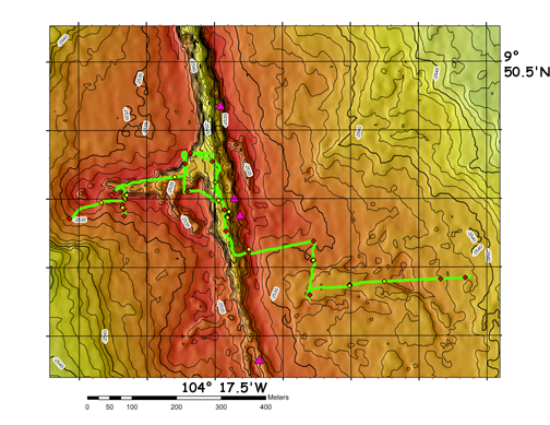
east rim of axial summit collapse trough (ASCT) of EPR near 104°17.5'W,
9°50.3'N, 2510 m water depth.
Purpose: Investigate nature of breakout channels in ASCT
displayed in ABE micro-bathymetry and DSL-120A sonar data
Observations: The dive commenced near a prominent breakout
channel located along the west rim of the ASCT. The channel was
crossed several times along north-south traverses and found to
be floored with curtain-folded sheet lava with prominent lava
pillars and collapse features along the channel margin. The depth
of the channel is ~5-6m, which corresponds well to the ABE micro-bathymetry
data. The channel leads directly from the area in the ASCT where
some of the strongest hydrothermal activity was observed in 1991
during the eruption, and which continues to be a locus of high-temperature
hydrothermal activity. Time was taken during the dive to sample
(via slurp and manipulator) biological mat material and animals
from the east side of the primary fissure system just north of
Bio9 vent and near the high-T vent for guest investigators on
board (personnel from The Institute for Genomic Research). The
dive then continued down the east rim of the ASCT to a position
north of a main breakout channel observed in the ABE and DSL-120A
sonar data. The channel was found to be ~100m wide and consists
of a prominent contact between collapsed lobate flows outside,
and sheet flows with variable surfaces (from flat to lineated
to curtain folded). Samples were collected from the curtain folded
flows within the channel and lobate lava outside the channel for
geochemical and magnetic analyses. Additional observations are
needed along the western end of the channel where it begins near
the ASCT to determine whether it is continuous with the ASCT rim
or is fed by lava tubes issuing from the ASCT. Additional samples
are also needed from flow fronts that form the scalloped morphology
observed on the east and west sides of the ridge crest. These
objectives and additional work in the 9° 28'N area, will form
part of the primary work to be accomplished in Spring, 2003 when
the remaining dives will be conducted.
May 17 & 19
Alvin Dives #3785 and #3787
Science Observers:
Ken Macdonald and Rachel Haymon
Alvin Pilots: Phil Forte (D3785) Blee Williams (D3787)
Location: 30 kilometers west of the East Pacific Rise near
9° 28'N
As a part of an NSF-funded project (OCE-9816021) Macdonald reviewed a large number of Alvin dives from the Mid-Atlantic Ridge, and the East Pacific Rise. On Dive 2699, a pilot-in-training dive conducted in 1994 which was poorly documented, dozens of chalky white mounds were found and thought to be hydrothermal in origin. NSF funded a two dive reconnaissance program to investigate these mounds as an augmentation to this grant.
On Dives 3785 and 3787, Macdonald and Haymon relocated and mapped over 100 mounds of light colored sediment sitting on top of the darker sediments that blanket the top of an abyssal hill (see Photo 1). We found that most of the mounds lie at the margins of crater-like depressions in the sediments, approximately 0.5-1 m across, and appear to contain ejected chunks of sediment. Eleven push cores of the mounds (Photo 2), and of the sediments within the craters, and the darker sediments outside mounds were collected. Temperature gradients were measured in the sediments, and these measurements showed that there is a significant flux of heat from the top of the abyssal hill (approximately 10-15 heat flow units), even though no visible venting of fluids from the seafloor were observed during the dives. During Dive 3785, we encountered structures on the fault scarp that appeared to be old (inactive) hydrothermal chimneys (Photo 3), but they were so indurated we were unable to sample them without a rock drill. If they are hydrothermal chimneys, as they appear to be, it means that focused hydrothermal fluid flow has occurred along the fault relatively recently. Other samples collected during the dives include 3 "slurp" samples of mossy material on the fault scarp, and rock samples with moss-covered surfaces. This material is probably bacterial in origin, its growth enhanced by diffuse hydrothermal flow along the 200 m high fault scarp. Water temperature measurements along the scarp showed 150-200 millidegree temperature anomalies.
After the dives, Haymon and UCSB graduate students Sara Benjamin and Jeff Blasius sub-sampled the push cores, while Eric Olson (University of Washington) analyzed some of the samples for methane and hydrogen. More analyses of the sediments and pore fluids in the cores will be done this summer at UCSB to look for clues about the origin of the mounds and craters. Preliminary observations of the layering in the cores suggest that the light-colored sediment was ejected from the craters and deposited on top of the surrounding sediments. Chemical and mineralogical analyses of the cores will provide more information about how and why these "blow outs" occurred. The alleged bacterial growth along the fault scarps will be analyzed to see if it really is bacteria by Rachel Haymon and David Valentine at UCSB and its DNA will be analyzed at The Institute for Genomic Research.
This finding is potentially very important because hydrothermal activity has been documented only along the axis of fast-spreading ridges. The only other off-axis sites have been along large/deep faults on the flanks of slow-spreading (Lost City) and intermediate spreading ridges (Middle Valley and Galapagos Mounds). The lack of identified off-axis hydrothermal activity at the fastest spreading rates has been a puzzle for decades. Our initial findings suggest that hydrothermal activity may be common in the off-axis environment of fast-spreading ridges, especially along large offset normal fault scarps.
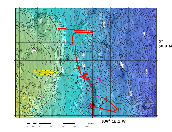
ABE Dives #63-#65
May 16 ABE Dive
#63
Successful test dive across the western half of the CAMH at ~9°50.5'N
to test vehicle functions and navigation net. Dive lasted ~2 hrs.
on bottom short duration of dive necessitated by need to
transit to Macdonald dive area.
May 17 ABE Dive
#64
Dive aborted because
of propulsion motor connector failure at 1300 meters.
May 18-May 19 ABE
Dive #65
ABE surveyed an
area covering ~1 km (north-south) by ~2.5 km (east-west) of the
western flank of the EPR near 9°50'N out to 2.5 km from the
axis.
Purpose: To map the magnetic field and seafloor morphology over an area that mirrored the the northernmost I km of the eastern flank mapped with ABE in November 2001. Of particular interest is the nature of the western edge of the CAMH, which, on the eastern flank, is extremely linear, razor sharp and parallel to the EPR axis.
Operational Report: ABE Dive 65 began on May 18 and was completed on May 19. The bulk of the dive occurred unattended, while Alvin Dive 3787 was underway at a site ~30km from the ABE survey site. ABE completed approximately 40 km of track lines over 16 hours of survey time. The mission terminated when battery power was depleted.
The goal of the dive was to gather detailed bathymetry and magnetics on the west slope of the 9° 50' site, where ABE had successfully mapped the eastern slope on our previous cruise (AT7-4). Track lines 1km in length were planned along-axis with 60 meter spacing. ABE's nominal height off bottom was programmed to be 40m.
ABE was launched at 1846L on May 18 directly over the starting spot. From Atlantis, we watched ABE descend to the desired starting spot, which it reached 2.5hrs later at 2508m depth. While Atlantis conducted tests of the new WHOI camera sled, we observed ABE executing the first track lines without incident. The camera sled was recovered while ABE continued the survey. We left the site at 0500L on May 19 in order to reach the Alvin dive site on time.
After the Alvin D3787 recovery, we began the 2.5 hr transit back to the ABE site. When we were approximately 2.5km away, we heard transponders pinging and nearly simultaneously picked up ABE's RF beacon, indicating that the vehicle had surfaced. Atlantis headed in the indicated direction, and we spotted ABE's strobe lights on the surface 14 minutes later when we were only a few hundred meters away, visibility was significantly reduced since it was not yet dark. Within 20 minutes, ABE was recovered without incident.
We downloaded the data files and confirmed that ABE had covered the desired survey area. When the batteries were depleted, ABE had executed 42 track lines. each approximately 1 km in length. In the steep terrain to the west, ABE could receive only one transponder much of the time, when it dead reckoned. Navigation fixes for most of these periods were recovered in post-processing using surface bounce returns. Processing of the bathymetry proceeded smoothly using the recovered navigation fixes and a small amount of dead reckoning. New angular calibration parameters were determined for the scanning sonar, which had been removed and remounted during the ABE repairs.
Science Observations: The morphology on the west flank of the ridge crest shows the scalloped nature also found on the eastern flank and attributed to semi-circular fronts of individual lava flows. In the west flank magnetics, the western edge of she CAMH shows none of the sharp linearity that characterizes the eastern edge on the other side of the axis. Instead, the CAMH appears directly related to 3-D rather than 2-D lava depocenters. The CAMH edge on the west flank of the 9°50'N area is the most 3-D anomaly mapped with ABE, whereas the CAMH edge on the eastern flank is the most 2-D (the quality of the CAMH edges in the EPR 9°28.5'N is somewhere in between). The fact that the CAMH is not symmetrical about the spreading axis rules out the possibility that the CAMH edge reflects geomagnetic field intensity fluctuations associated with the Laschamps event ca 35 kyr ago. The ABE imagery and Alvin dives so far strongly suggest that the CAMH reflects the deposition of young (<5 kyr), highly magnetic lava on the upper flanks of the EPR out to several km. The linearity of the eastern edge of the CAMH it attrbuted to a linear depocenter that is controlled by the normal fault inspected during Alvin Dive 3784.
ABE successfully met its goal for this cruise by mapping a 1-km wide section of the CAMH and collecting micro-bathymetry on the western flank of the EPR crest in the 9°50'N area.
Towed Digital Camera
and Multi-Rock Corer System Trials
The new towed digital
camera and multi-rock corer system funded by NSF was completed
during the cruise and tested. Several shallow water tests were
done to ensure digital camera functionality and measure the scale
of the photo coverage underwater at 3m, 5m and 7m altitudes, typical
of normal towing conditions. The camera is a new product of Deep
Sea Power & Light (DSPL), San Diego, CA developed in collaboration
with D. Fornari for this grant. The results are: at 3m altitude
the image is 3.5m x 2.6m, at 5m altitude it is 6m x 4.5m and at
7m altitude it is 8m x 6m. The cameras have also been extensively
tested on Alvin in both forward-looking mode using HMI lights
and in down-looking mode using two (2) 300 watt/sec. Benthos 383
strobe heads. Images are excellent. Additional experimentation
will be done on the Galapagos leg to determine optimal positioning
and lighting.
One deep water test of the camera/corer system was done that provided data on how long the winches should operate on reel-up of the corer heads after triggering (it was 2 minutes originally but has since been lengthened to 4 minutes after the test). All 3 winches tested functioned well and collected basalt glass from ~5m altitude. The camera did not function because of a bad connector. This is being replaced and the entire system will be tested on the next leg at the Galápagos Rift. The DSPL cameras
Documentation of the system is ongoing and a manual will be produced prior to the planned use of the system at Hess Deep for E. Klein of Duke U. and D. Smith of WHOI. Members of the WHOI- AOPE Dept. are to be congratulated on their exceptional engineering and fabrication of the system over the past 5 months. Key individuals involved are: Andy Billings, Rod Catanach, Steve Liberatore, M. Swartz, T. Hammar, K. Doherty, A. Duester, G. Meier, M. Gould, A. Bradley, and B. Walden.
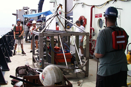
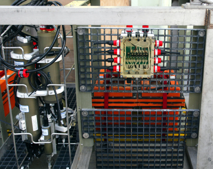
Towed Digital Camera and Multi-Rock CorerSystem ready for deployment. The system is towed from the CTD cable in order to provide standard CTD and water properties data, as well as digital depth and altimetry to correlate with imagery. Orange boxes along center-line are DSPL 24 VDC batteries. 2 batteries power the strobe and the other two batteries power the camera and winch system. The CTD is powered via the seacable. Strobe heads are located at either end of the sled providing ~3m of separation. Camera is mounted in center of the frame.
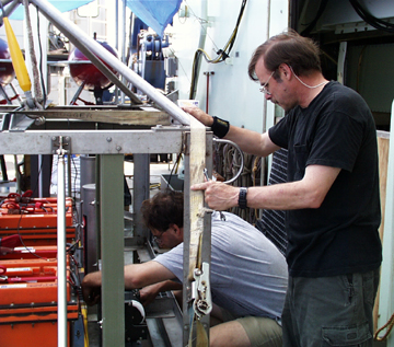
Steve Liberatore (standing) and Andy Billings working on the camera system.
View of the starboard side of the sled showing power junction box (right) and SeaBird SBE25 CTD unit (green housings on tubular frame).
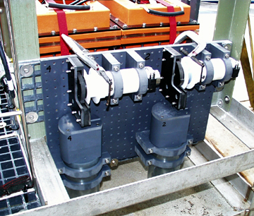
Rock core units mounted on the camera system. The units are designed to be modular for ease of mounting and servicing to recover samples. At present the system is capable of deploying 6 rock corers per lowering. The electronics have been designed to permit deployment of up to 12 corers per lowering.
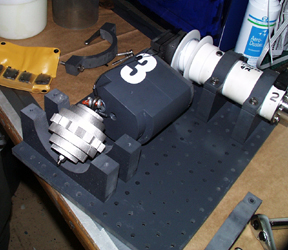 Rock
corer unit on the bench showing the stainless steel head which
is coated with surfboard wax (see photo below). Core heads are
connected to the winch spool on a ~8m long 250# test monofilament
line.
Rock
corer unit on the bench showing the stainless steel head which
is coated with surfboard wax (see photo below). Core heads are
connected to the winch spool on a ~8m long 250# test monofilament
line.
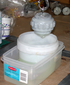 Rhian
Waller devised an excellent way to coat the rock corer heads by
melting the wax and repeatedly dipping them to coat the surfaces.
Rhian
Waller devised an excellent way to coat the rock corer heads by
melting the wax and repeatedly dipping them to coat the surfaces.
Alvin Frame-Grabbing
Prototype
S.Lerner - WHOI, in
collaboration with the Alvin shore-based and at-sea operations
group provided software and hardware to test the capability to
automatically frame grab 640x480 images from the continuous video
recorded on Alvin. Images were captured every 30 seconds and the
system worked very well and recorded data for all the dives. Data
were downloaded and made available to shipboard scientists via
the shipboard network following the dives. The images appear as
thumbnails keyed to critical vehicle data and navigation and can
be rapidly scanned for post-dive analysis.
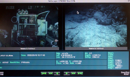
Example of Steve Lerner's (WHOI) Alvin frame-grabbing system showing simultaneous input from the two video cameras in use on Alvin Dive 3786. Boxes below images show relevant vehicle and sensor data and navigation information for time corresponding to when each image was taken.