|
Message #10
Tuesday - April 6, 1999 1700 hrs 61 15.544S 51 07.722W
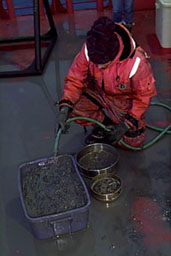
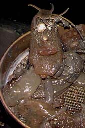
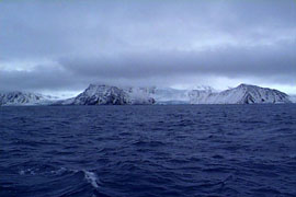
Wednesday April 7 1999 0730 hrs 60 06 S 55 10 W Elephant Island. If there is one island or landmark that is best known in this region, this is it. This is the spot where the Shackelton Expedition finally set foot on land after their ordeal in the ice pack of the Weddell Sea over 80 years ago. Anyone who comes to Antarctica has read the stories and books about that extraordinary adventure, so this morning, everyone was out on deck to see the Island for themselves. Elephant Island gets its name from its shape, which looks like an elephant's skull and ears in profile, with the eastern end being the long, extended trunk pointing towards the Orkneys. Our sampling station was right about where the Elephant's mouth would be, sheltered by land to the west and north. The day was overcast, with light snow, so visibiity was not great, at least initially. The low clouds cut off the peaks at high elevations, giving us a horizontal slice of the island. I've attached a photo so you can see for yourselves. The map tells us there is a 3000 foot peak up in the clouds, but we can't see it. Just out of the picture and to the right is Endurance Glacier - a huge glacier wall that extended to the horizon along the coast - definitely the widest glacier we have yet seen. It can't extend that far away from us into the interior of the island, since the island itself is only a few miles across. As we waited for the boat to get to our station, many of us scanned the coastline with binoculars, imagining we were with Shackelton, wondering where we might pick a spot to land after months stranded on a drifting ice pack and then a week in small boats after the ice broke up. We could see why he had gone to the other side of the island, since there were only steep cliffs and glacier walls where we were. I would expect that the island has changed little even after 80 years and this was much the same view that confronted that expedition. They must have been thrilled to see land after such a long time, but that first view was far from a hospitable sight. Again, I highly recommend any of the books about the Endurance expedition. One I finished on the trip down here is simply called "South", written by Shackelton himself. Thursday - April 8 0530 hrs 62 09.4 S 58 25.0 W Admiralty Bay We entered Admiralty Bay at sunrise - everything was dark, but we could see the lights of two of the stations within the bay. Poland had a station to our left, and Brazil to our right. Even at that early hour, they responded to our radio message and helped us choose a good sampling station. The Polish station kept asking us to stop in for a visit, which would have been fun and interesting, but would have taken time out of a day where every available minute was allocated to sampling or transit between sampling stations. In addition, we cannot land without explicit permission from the National Science Foundation, which was not possible on such short notice, and at that hour. Just about everythng you want to do in Antarctica requires permission. Everything is protected under the Antarctic Treaty. Once the sun had risen, we found ourselves in another bay where mountain peaks were interspersed with glaciers that came down to the waters edge, ending with that now-familiar glacial wall that occasionally collapsed into the sea. There was less snow here, and the tops of the glaciers looked "dirty" - as if it had not snowed for some time and the old snow was blanketed with a layer of dirt. We had chosen our sampling area because we expected it to be a sheltered cove, but found that even there, the wind was blowing 50 mph. Fortunately, it was quite warm - nearly 5 degrees C (41 F), so it was not unpleasant as long as the Captain kept the ship aligned into the wind, shielding us with the superstructure while we worked on the fantail. Sampling went very well for us - we found the softest bottom sediments yet, so all of the equipment worked well. There was not a lot of algae in the water, however, perhaps due to the high level of suspended sediment, presumably from the "dirty glaciers" and the dry soil of the land around us. By 0900 we were finished and on our way out, declining yet another offer from the friendly Poles to visit. As if in apology for the nasty windstorm we had encountered, we were rewarded with a rainbow over a glacier as we left the Bay - a nice touch that brought everyone out for another Kodak moment. 1330 hrs 62 12.0 S 58 48.3 W We are now in Maxwell Bay, which, relative to everywhere else we have been, is a veritable metropolis. As we came into this large bay, we saw the South Korean station on our right, and then on our left in succession: the Great Wall Station (China), the Chilean station, the Russian station, and finally the Uruguaian station. (Yes, I also wonder why a developing country like Uruguay would have a station in Antarctica). As it turns out though, when we tried to get some science information over the radio, we found out that nearly all of these stations were manned by military and not science personnel. The Chilean station, for example, houses scientists from November until February, after which they leave and only military personnel remain. I'm not sure what a military base is useful for down here, with only a handful of people and no ships or other heavy equipment, but that's what we were told. It was surprising and disappointing news. The land around us was different from what we had seeen elsewhere. Looking back on our cruise thus far, the Palmer Staton area and the Antarctic peninsula to its immediate north were mostly snow-covered mountains and glaciers, and water with many icebergs or brash ice. The landscape was pedominantly white, with the dark rock of the cliffs and peaks as a contrast. The Orkneys and Elephant Island were also jagged rock peaks jutting out of the ocean, with large glaciers and much snow cover, and grounded icebergs surrounding them. Now the areas we were seeing on King George Island looked more like barren hills of brown dirt or ash. There was very little snow, and the hillsides even had a hint of green - probably due to lichens or mosses. (The nearest tree is probably back in South America). I would guess that the island has a slightly milder climate due to its latitude and the fact that it was surrounded by water. There were several large glaciers, but they were not as white and pristine as the others we had seen, and icebergs were rare. Our sampling went very well here. For the first time, we found several clams of moderate size - about the size of a quarter. This may seem meager, considering that in a similar amount of mud in Buzzards Bay, we might find a dozen small clams, and we certainly wouldn't require a 240 foot vessel to get them. But simple things are not simple down here, where nothing is known about the bottom sediment types or the kinds of organisms that live in different places. Every station is an unknown to us, so many times we do not find what we are looking for. Now we can note that Maxwell Bay is a good place to find shellfish, and others can benefit from that knowledge in their research. The clams in the grab samples prompted us to lower a dredge that we had jury-rigged from an old scallop dredge - we beefed it up for use in much deeper waters from a much bigger ship. After only a 10-minute tow, it came up with a great sample of the bottom community of organisms - and now we have more than enough small clams for toxin assays. Slowly, we are learning how to modify our methods to collect good samples in these waters. What worked around Woods Hole or the Gulf of Maine does not necessarily work here, so it has taken time to adapt and adjust. Pam Arnofsky, the benthic ecologist on our team is constantly amazed by the animals she is sieving out of the mud brought up by the Smith MacIntyre. (As is true for all of us, this is her first trip to Antarctica). She couldn't be happier than when she is elbow-deep in gooey clay, washing the mud through sieves to reveal all the strange creatures that live in the mud far below us. This is such an unexplored region of the world's oceans that it is quite possible that some of the organisms she will see will be new to science. I've attached two photos, - one of Pam sieving the mud on deck, and another of the different worms, tunicates, sea cucumbers, starfish, and so forth that she has collected at the end. (If the strange creature at the top of the image looks like a Mr. Potato Man from the deep, it is just a coincidence). Some of these animals will be used in our tests for algal toxins, and others will be sent to experts all over the world for identification.
Now we are transiting to our third station for the day - Discovery Bay on Greenwich Island. We will hit that one after 1900 hrs, so we will work in the dark. After that we will move out into more open waters deploy what is called an otter trawl - a net stretched between two wooden doors that bring the net down to the bottom and keep it stretched. It's a good way to catch fish, but in our case, we want krill, the tiny shrimp-like animals that eat the algae. The other nets we have been using to catch krill have not worked well - they look like large wind socks with a collecting can at the small end - they are about 1 meter in diameter, and 3-4 meters long, but they still are not big enough to catch krill, which are hard to find right now. The krill tend to swim towards the surface waters at night, so by sampling late, we should have a better chance to get them. Their strategy is to go up into the water column at night to avoid predation, but we will be there waiting for them. Tomorrow will be a big day. We will be spending all day at Deception Island, which is actually a submerged volcano. There is a very narrow opening into the center of the volcano called Neptune's Bellows, and this large ship will barely fit through there. (As a reminder of how treacherous it can be, there is a wreck of an old whaling or sealing ship on the rocks at the entrance). Once inside, it is an open, round area of water about 3 miles in diameter, surrounded by the inside walls of the volcano, which last erupted about 30 years ago. This is the place where we have had reports of dead penguins, but it is also the kind of environnment where water is flushed out slowly, and where toxic algal blooms might well develop and persist. It's also a place where dead and dying algal cells and their resting stages will fall to bottom sediments and not be washed away. The fact that it is a spectacular landscape, that there are numerous penguins to see as well as hot springs and an abandoned whaling station are purely coincidental and have nothing to do with our decision to sample there, I assure you. |
 What a difference a day
makes. The weather today is much, much better - just a rolling swell, and a very
smooth ride, at least compared to what we went through last night. The rest of
today will be for transit to our next stop - Elephant Island, which is over 300
miles west of the South Orkneys. Our plan is to be there around daybreak, to
sample at only one station, and then to continue west and south to King George
and Livingston Islands. The island is so isolated and exposed, we don't expect to
find the types of sediment deposits or bloom populations we are looking for. But
we will take samples anyway, and then continue on. Slowly but surely we are
working our way back towards Palmer Station, where we hope to be on the 11th
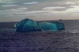
after nearly two weeks on this leg. The water here is generally free of icebergs,
but we did pass a few, including a nice one that was translucent. I've attached
the photo.
What a difference a day
makes. The weather today is much, much better - just a rolling swell, and a very
smooth ride, at least compared to what we went through last night. The rest of
today will be for transit to our next stop - Elephant Island, which is over 300
miles west of the South Orkneys. Our plan is to be there around daybreak, to
sample at only one station, and then to continue west and south to King George
and Livingston Islands. The island is so isolated and exposed, we don't expect to
find the types of sediment deposits or bloom populations we are looking for. But
we will take samples anyway, and then continue on. Slowly but surely we are
working our way back towards Palmer Station, where we hope to be on the 11th
after nearly two weeks on this leg. The water here is generally free of icebergs,
but we did pass a few, including a nice one that was translucent. I've attached
the photo.
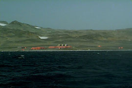 Maxwell Bay is apparently one of the most popular stops of
the tourist ships that come to Antarctica - they bring in people, Zodiac them to
shore where they visit the penguin rookeries, seal colonies etc. Apparently, the
Chilean base even has rooms to rent - if you came here on your own boat somehow,
(and I'm sure there are crazy sailors who brave these rough seas in small boats
to do just that), they will put you up for a fee, much like a hotel. Don't get me
wrong though - the conditions must be spartan - similar I'm sure to what we see
at Palmer Station - metal buildings, muddy paths and roads, food that is
delivered once every few months, de-salinated water to drink, etc. I've attached
an image of the Korean base so you can see the way another station looks. The
base was quite far away, so it's not a great image, but the photo also shows the
color and shape of the surrounding landscape. It's very different from past
pictures I have been sending of the Antarctic coastline.
Maxwell Bay is apparently one of the most popular stops of
the tourist ships that come to Antarctica - they bring in people, Zodiac them to
shore where they visit the penguin rookeries, seal colonies etc. Apparently, the
Chilean base even has rooms to rent - if you came here on your own boat somehow,
(and I'm sure there are crazy sailors who brave these rough seas in small boats
to do just that), they will put you up for a fee, much like a hotel. Don't get me
wrong though - the conditions must be spartan - similar I'm sure to what we see
at Palmer Station - metal buildings, muddy paths and roads, food that is
delivered once every few months, de-salinated water to drink, etc. I've attached
an image of the Korean base so you can see the way another station looks. The
base was quite far away, so it's not a great image, but the photo also shows the
color and shape of the surrounding landscape. It's very different from past
pictures I have been sending of the Antarctic coastline.