Continental Shelf Parameters
Inferred from
SAR Internal Wave Observations
ResultsAbstract This paper shows a preliminary results on the use of Synthetic Aperture Radar (SAR) imagery to extract oceanographic information about the continental shelf. The surface manifestation of internal waves is observed using the Synthetic Aperture Radar (SAR) onboard the European Research Satellite 1 (ERS-1). The depth of the pycnocline and the density of the surface layer can be estimated from the dispersion relation obtained from a two-layer fluid model. The other parameters that are required to make this estimate are obtained by assuming climatological bottom density, estimating the speed of propagation from the tidal-generated wave packets, and calculating the depth of the pycnocline based on the isobath where the internal waves are dissipated. This robust method for obtaining quantitative information about the structure of the shelf's water column shows good agreement with the in situ observations from that area.
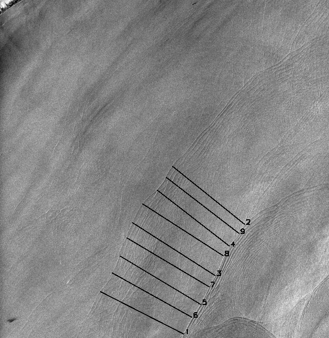
Figure 1 is a SAR image from ERS-1 of the
waters just south of central Long Island. The image is 100km on the side.
The internal wave crests in this image are one tidal cycle apart, (i.e.,
12.42 h) and by measuring the distance between the wave packets we can
estimate their speed of propagation. Fgiure 1 shows nine lines equally
spaced along the wave crests of two internal-wave trains whose generation
time is assumed to be separated by 12.42 h. We have averaged the length
of the nine lines and divided that by the tidal cycle period to obtain
a speed of 0.62 ± 0.06 m/s, which is within the range of speeds
observed in the New York Bight by Liu [1988].
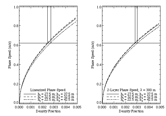
Figure 2. Phase speed vs. density fraction
computed from linearized relationship (left panel), and full 2-layer dispersion
relation (right panel) for several combinations of layer depths. The horizontal
line shows where a phase speed of 0.62 m/s intersects the various curves,
and the vertical lines indicate the error bounds on the density fraction
corresponding to the depth variations.
There are, of course, several caveats that
need to be stressed in connection with discussion presented above. First
of all, one must keep in mind that SAR observations are time limited. This
means that an estimate of the location of the dissipation region may be
in error simply because the waves haven't yet propagated further onto the
shelf at the time of the image. This usually results in an over-estimate
of the critical depth (and the pycnocline depth). Also, there will certainly
be cases when the water column is not well characterized as a simple two-layer
system. Especially near the shelf break for example, a thin but well-defined
bottom layer is sometimes observed below the usual two-layers typical of
the region further in shore [Lynch, et al., 1997].
CONCLUSIONS
We have shown in this paper how it may be possible to remotely estimate various properties of the water column on the continental shelf using SAR imagery in conjunction with knowledge of the local bathymetry, climatological density data, and simple models for internal-wave evolution. Theoretical studies of two-layer fluids indicate that dissipation of internal waves impinging on shoaling water occurs when the depth of the bottom layer, which is decreased by the shoaling, becomes equal to that of the upper layer. Using this idea, we have determined this critical depth for a particular case study by noting the location in the SAR image where the internal-wave surface signatures disappear. The depth of each layer at this position is then half the total depth. By assuming that the internal waves are generated at the shelf break on each diurnal tidal cycle, we have also estimated their phase speed by measuring the distance between successive packets in the image. With this information along with the 2-layer dispersion relation, we have been able to estimate the fractional density change between the two layers. Furthermore, an estimate of the surface density is possible by using the climatological bottom density. We have compared the parameters extracted using these methods with in situ measurements collected concurrently with the SAR imagery. This comparison showed good agreement, and gives us confidence that our techniques are robust.
REFERENCES
Lynch, J. F., G. G. Gawarkiewicz, C. S.
Chiu, R. Pickart, J.H. Miller, K. B. Smith, A. Robinson, K. Brink, R. Beardsley,
B. Sperry, G. Potty, 1997: Shelfbreak PRIMER - An Integrated Acoustic and
Oceanographic Field Study in the Middle Atlantic Bight. Proceedings:
Shallow Water Acoustics Conference, Beijing, China, (in press).