Denmark Strait: 19: The Faroe Islands
Dallas Murphy
September 17, 2011
The Faeroes may be another of those places better revealed by imagery than language. So, unwilling to compete for fear of flamboyant failure, I’ll offer but a few ash-dry sentences, eschewing the purple, and step aside to let the photographers evoke place, time, and light. That we’re here in the Faroe Islands at all was a gift from Bob (and Knorr’s people who got us here, including but not limited to Jen, who did the nav without detailed charts and Kyle, whose birthday it was, 9/17, and who oversaw the boat launching) to the CTD ladies for their unstinting, month-long labor.
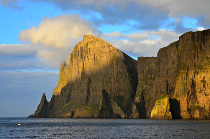 "Grendel's Lair" © Rachel Fletcher
The eighteen Faroe Islands, with a land area of 540 square miles and 694 miles of coastline, lie in the open North Atlantic midway between Iceland and northern Scotland at 62°00’N by 006°47’W, the position of the capital and largest town, Tórshavn. The islands are tightly clumped and separated by narrow fjords, suggesting that once there was a single island, perhaps of volcanic origin arising, like Iceland, as a result of tectonic activity on the Greenland-Scotland Ridge. There’s evidence in the rock of volcanism; and the passing of the Pleistocene glacier is riven into the landscape, evident not only in the fjords themselves but in other glacial features, cirques, couloirs, and arêtes. Those two forces, fire and ice, along with a lot of erosion have sculpted these islands. But that’s to get ahead of the story.
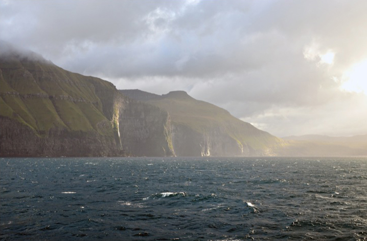
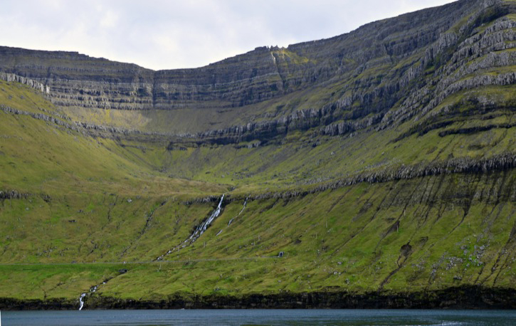 A road crosses this waterfall in the Faroe Islands and into a tunnel system which connects each town. © Rachel Fletcher
It began about 0800, landfall imminent, when the gawkers and the remarkers began to gather on the bridge, lining the bench at the after end, while Jen tried to navigate around us. She had chosen to round long, thin Kalsoy Island lying at the north end of the group. The fog was thick, and the Faeroes, still eight miles away, appeared first as a dark smudge, but even from that remove it became clear to the gallery that we were approaching a truly spectacular landscape. A half hour later, patches of blue sky struggled through the fog. Were we going to get lucky still again, as we had on our approaches to Greenland and Iceland? Ten minutes later we variously gasped, whistled, or exclaimed profanely at an astounding piece of geology.
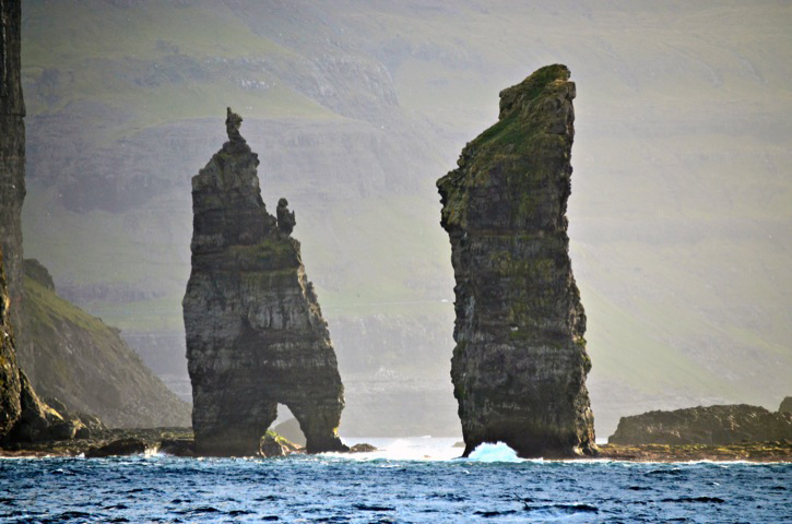 Sea stacks rise out of the sea. © Rachel Fletcher
A mountain—actually half a mountain—soared up out of the black sea. It was a 700-meter high vertical naked-rock face, brooding wisps of off-white fog hanging near the summit, the timid sun glinting on the wet granite. On the landward side, the mountain eased down at a reasonable slope, but not on the seaward side. Something unimaginably violent had happened here in the deep past; something cataclysmic had cleaved away half of a mountain, leaving its innards exposed to the wind, the waves, and us. We fell silent; that doesn’t happen often and never for long.
“That’s where Grendel lives,” said Pete after a time.
He was right. Geology, plate tectonics—no, not science; myth best explained this place. A trio of thin, sharp crags, remarkably human-like, stood atop the cliff, as if from a Nordic pantheon in a souped-up Wagner set, brooding on the loss of half their aerie. At the foot of the cliff stood two huge sea stacks, cores from the lost half, like Rodin sculptures.
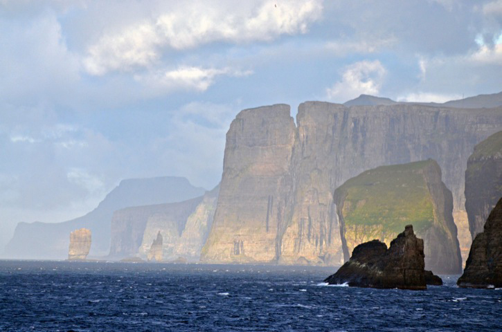 The beginning of another sea stack can be seen at the top of this mountain. © Rachel Fletcher
Yeah, but there was still serious nautical matters to attend, and I was glad they didn’t fall to me, leaving me and the gawkers to respond as we would to the spectacular, exotic land- and seascape. The Skip had come onto the bridge with his inevitable mug of coffee. I noticed first what he didn’t do. He didn’t look over Jen’s shoulder at the chart table, no second-guessing. Her work was good; and he so assumed. (I love watching the way this ship works if you haven’t noticed). He took his place on the starboard side, and after a while, asked, “What do we have on line?”
“One big and a small,” said Jen.
“Let’s put on another big.” In close quarters, the loss of one big (sixteen-cylinder) engine, unlikely as it was, could put her on the ground.
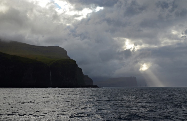
 Water glistens on the sheer rock face of the Faroe Islands. © Rachel Fletcher
We entered Kalsoyarfjødur, Kunoy Island on our port hand. (By the way, check some of these names, copied from the chart, of nearby places and features: Fuglafjørdur, Oyndarfjørdur, Funningsfjørdur, Gotuvk, and Haraldssund that evoke Vikings in longships and knarrs stopping for a rest en route to Greenland.)
Once in the fjord, the granite of Grendel’s lair gave way to white sedimentary rock banding the green, pyramidal mountains like guitar strings. Then we began seeing farms and tiny settlements, each with a red-roofed church, nestled in the looping saddles between mountains. The shorelines on either side were steep-to, nowhere to land a boat. The isolation was exquisite.
 The varying coastlines of the Faroes with waterfalls, sea stacks and sheer drop-offs. © Rachel Fletcher
“Jen, please give the engine room five minutes notice for the bow thruster.” Knorr is safe in open ocean. Danger comes when hard bottom is nearby. The Skip asked Jen to call Kyle to ready the anchor for a quick drop, and Kyle spent the rest of morning standing-by on the bow. Sightseers soon joined by him. Others lined the rails; still others joined us on the bridge. A shoreline road appeared and periodically vanished into tunnels. How could they have possibly gotten construction equipment into these places, where the mountains sloped 45° down from towering points? We saw barn-like buildings standing utterly alone in steep valleys seemingly accessible only by helicopter. I read subsequently that dried mutton was the national dish. Could these be drying sheds? But why were they built in such isolation, where the farmer risked life and limb to climb over the sharp-rock mountain peaks on either side to reach his mutton?
From shore we must have looked like a cruise ship, photographers on the bridge wings, the flying bridge, and the main deck as we traveled down the fjord for over an hour past the mountains and the tucked-in towns of about twenty buildings each, all neat and spiffy. And then we stopped at the foot of the fjord between Kalsoy and much larger Søvágur Island in order to explore in the small boats.
I was a member of the first boat tour, having lurked at the starboard side ready to go in life vest and hardhat as they craned the RHIB off of the 02 deck and placed it at the rail for boarding.
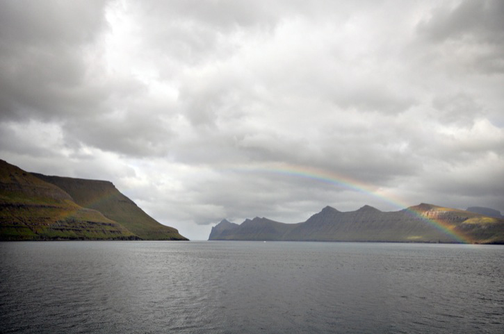 This rainbow took nearly an hour to form across the fjord. © Rachel Fletcher
“Stay away from the town,” said Kyle to Jose, the boat driver. There is an informal international agreement allowing research vessels to enter foreign waters for scientific work. Like Greenland, the Faeroes are a self-governing dependency of Denmark, but we had no Danish clearance to land. So we sped off in the opposite direction from town to explore the wild shoreline close aboard from where the massive scale of the landscape became clear. There was a terrace of rock at the waterline where a boat might land, but landing would be pointless for the farmer trying to tend his sheep grazing farther up the steep mountainside, because he would be confronted by a sheer fifty-meter cliff. Yet there were the sheep, grazing up on hair-raising slopes and seemingly impossible ascents to anywhere else.
|
And here was another of those pure, exquisite moments so valuable in experience yet so quickly passing into memory, precious and unforgettable. |
And everywhere we looked glimmering ribbons of waterfalls ran down ravines into the sea. The waterfalls emerged from out of the rock itself, not from the top of the mountains, as though the islands had their own internal reservoirs—which is likely the case, since the Faeroes receive 260 days of rain per year. Then as we returned to the ship for the next riders’ turn, a perfect rainbow of purple, orange, and yellow materialized from the clouds, arced over the mountain down to sea level as if Bob had staged it as part of his gift. And here was another of those pure, exquisite moments so valuable in experience yet so quickly passing into memory, precious and unforgettable.
That said, I’ll step meekly aside and let the photographs portray the experience.
Last updated: December 27, 2011
Copyright ©2007 Woods Hole Oceanographic Institution, All Rights Reserved.
Mail: Woods Hole Oceanographic Institution, 266 Woods Hole Road, Woods Hole, MA 02543, USA.
E-Contact: info@whoi.edu; press relations: media@whoi.edu, tel. (508) 457-2000
Problems or questions about the site, please contact webdev@whoi.edu