|
 |
| |
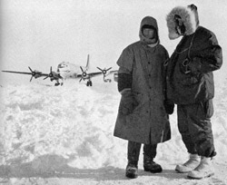
Airmen bundled against
Minus 20° cold survey their snowbound domain in the
polar sea. Image courtesy U.S. Air Force. |
History
US Arctic Drifting Stations (1950s-1960s)
While Soviet postwar activities in
the Arctic were unknown to the west until 1954, the US Air Force
began B-29 reconnaissance flights to the region beginning in
1946. Surprisingly, several large ice masses were spotted in
the deep basin, which were later determined to be icebergs which
had broken off and drifted from the ancient glacial ice foot
of northern Ellsmere Island. By 1951, daily reconnaissance trips
to the Pole were being implemented, and the drift of three large
ice island targets (T-1, T-2, and T-3) were being tracked. The
following year, the Alaska Air Command organized Project ICICLE
in order to establish a weather station on one of the ice islands
and conduct geophysical research. Joseph O. Fletcher was put
in charge of the project, and ice island T-3 was selected as
the site.
In March 1952, a C-47 aircraft from Thule Air Base landed on
T-3, which was seven miles long and protruded 50 feet above
the surrounding icepack, and the station was installed. Insulated
huts were flown in sections to the ice island (which was renamed
"Fletcher's Ice Island") and assembled by members of the military.
Scientists (led by Alfred P. Crary) arrived soon after and performed
numerous scientific investigations including hydrographic measurements,
seismic soundings, and meteorological observations. The station
was abandoned in May 1954 (when the weather observations were
deemed redundant with nearby Canadian weather station Alert)
but was reoccupied from April to September 1955.
 |
|
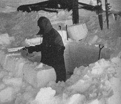
| Saw and shovel build
a house of snow blocks to shut out icy winds. Image
courtesy U.S. Air Force. |
|
The International Geophysical Year (IGY) planned for 1957-1958
stimulated interest in the US for occupying two drifting stations
in the Arctic. Project ICESKATE (again under the command of
Fletcher) was formed to install station ALPHA on a drifting
ice floe, and station BRAVO would reoccupy T-3.
In April 1957, the first ski-equipped C-47 landed at 79ºN, 159ºW
in order to install the ALPHA camp. By the end of May, a 1500
m long runway and most of the camp's 26 Jamesway huts had been
completed, and scientific operations commenced. Typically between
25 and 30 military and scientists manned the camp at any time.
During April of the following year, the ice floe began to crack,
and the camp was moved 2 km away. Drifting generally north then
east, ALPHA was visited by the submarine USS Skate in August
1958. Afterwards, the ice began cracking and ridging again so
the camp was finally abandoned in November. However, there was
still interest in continuing research started at ALPHA, so in
April 1959, station CHARLIE (also known as ALPHA II) was established
at 75°N, 158°W by the Alaska Air Command, with assistance from
the Navy's Arctic Research Laboratory in Barrow, Alaska. Scientific
work was conducted from June 1959 until January 1960, when the
ice floe cracked, shortening the runway so that CHARLIE had
to be evacuated.
Meanwhile, in 1957 the Northeast Air Command established BRAVO
on T-3 by bringing in 42-foot long commercial house trailers
on C-130s equipped with skis. The reoccupied ice island drifted
west off of the north coast of Canada, arriving in Alaska waters
by July 1959, where air support responsibilities were transferred
to Alaskan bases. In May 1960, the ice island went aground at
near Wainwright, Alaska, making study programs ineffective.
The following year, in October 1961, it was abandoned again,
with the station left intact for possible future use.
|
 |
| |
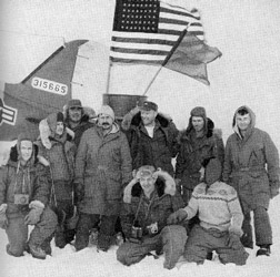
Air Force party posing
at the North Pole - the men flew 100 miles from Fletcher's
Island to make scientific observations at the pole.
photo U.S. Air Force. |
The Navy was still eager to continue operations in the Arctic,
so as a replacement for CHARLIE, the Arctic Research Laboratory
(under Max Brewer) sought to install a drifting station in May
1960, but balked at the costs required to charter a C-47 for
the installation. As a result, the following September icebreaker
Burton Island was used to transport the equipment to
75°N, 137°W, and the Arctic Research Laboratory Ice Station
I (ARLIS I) was constructed in 40 hours with help from the ship's
crew. Though intended to support 8 scientists and 4 camp personnel,
ARLIS I never achieved a full complement. Small Cessna-180 aircraft
were used for resupplying the station as it drifted westward,
but upon approaching the range limit of these aircraft, the
station was evacuated in March 1961.
For the second Arctic Research Laboratory Ice Station (ARLIS
II), a more permanent drifting ice station was desired, but
with T-3 grounded, a tentative site on an ice floe was selected.
However, during deployment in May 1961, chance resulted in the
finding of a 3.5 by 1.5 mile ice island north of Point Barrow
at 73°N, 156°W. Using R4Ds (the Navy equivalent of the C-47)
and Cessnas, all of the equipment to outfit the 14 prefabricated
buildings was transported to the ice island in 22 days. Scientific
operations commenced in June 1961, and continued all the way
into 1965. Resupply of ARLIS II during the first year was carried
out by Cessnas, later by airdrops from Lockheed Lodestars, by
the icebreaker Staten Island twice in the summer, and
by R4Ds. As the ice island drifted farther north, away from
Barrow and across the Arctic Ocean between 1962 and 1964, resupply
from Alaska became a bigger problem involving longer flights,
fuel drops, intermediate stops, and sometimes other aircraft
from the USAF and RCAF.
While ARLIS II was drifting away from Barrow, T-3 was rediscovered
in February 1962 over 100 miles north of where it had been previously
grounded. The Arctic Research Laboratory reoccupied the ice
island, refurbished the buildings, and the Navy was formally
given the station which served as a second drifting station
and a fuel depot for the flights to ARLIS II. ARLIS II reached
the most northern point of its journey at 88°39'N in December
1963 and eventually drifted out through the Fram Strait with
the East Greenland Current, with supply operations now proceeding
out of Keflavik Naval Station in Iceland. ARLIS II was evacuated
in May 1965 by the icebeaker Edisto after 47 months
and 18 days of continuous operation during which it was used
by 14 different research projects, including 337 different scientific
and support personnel. Upon completion of ARLIS II, a full occupation
of T-3 by the Arctic Research Laboratory was initiated in September
1965, which had completely circled the Beaufort Gyre. It remained
in continuous use until 1974, was last visited in 1979, and
eventually drifted through the Fram Strait in 1983, after being
monitored for over 30 years.
In addition, while the ARLIS II and T-3 ice stations were occupied,
the Arctic Research Laboratory established two temporary drift
stations northeast of Barrow primarily for studies of telluric
currents, geomagnetic variation and micropulsations, and aurora.
ARLIS III was established in February 1964 and was evacuated
in May of the same year, while ARLIS IV operated between February
and May of 1965.
References:
Cabaniss, G.H., K.L. Hunkins, and N. Untersteiner, compilers,
US-IGY Drifting Station Alpha, Arctic Ocean 1957-1958, Air Force
Cambridge Research Laboratories, Special Reports, No. 38, Bedford,
MA, 322 pp., 1965.
Farlow, J.S. III, Project Ice Skate Oceanographic Data, WHOI
Technical Report 58-28, Woods Hole, MA, 16 pp., 1958.
Fletcher, J.O., Three months on an Arctic ice island, National
Geographic, 103, 489-504, 1953.
LeSchack, L.A., ARLIS II: New Arctic drift station, Naval
Research Reviews, September: 12-18, 1961.
Sater, J.E., Arctic Drifting Stations, Arctic Institute
of North America, Washington, DC, 475 pp., 1964.
 Previous Chapter
Next Chapter
Previous Chapter
Next Chapter

|