We are developing optical water type classification approaches based on remotely-sensed water leaving radiance, with application to the study of spatial and temporal dynamics of ecologically and biogeochemically important properties of the upper ocean. In contrast to previous studies that have focused primarily on pigment distributions, our goal is to extract as much information as possible from the full set of spectral bands. Our initial work includes a regional study of optical properties in the northwest Atlantic based on CZCS and SeaWiFS data, as well as the detection and identification of phytoplankton blooms around the globe. With this preliminary study, we have established a basis for the application of feature-based approaches for the optical classification of water types. Future work will involve integrating in situ data into classifier development, and exploring the utility of both model-based and feature-based classification approaches.
A summary of our initial results is given here. A more detailed report of this work is included in the Ocean Optics XIV Conference Proceedings (10-13 November 1998, Kailua-Kona, HI), and is available for download (choose OOXIVpostscript or OOXIVmsword).
Phytoplankton-Dominated Waters
Click below to view CZCS images [normalised water-leaving radiances
(mW/(sr·cm2·mm)) and
pigment (mg/m3)] of phytoplankton blooms for which in situ
species and concentration data were reported in the literature (see table
below):
(right click on a link to open it in a new window...)
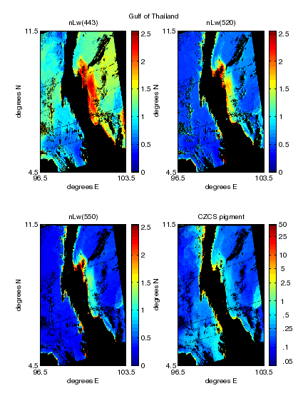
Gulf of Thailand
Northwest Australia
Southern California Bight
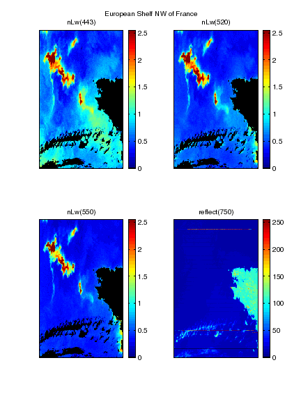
European Shelf NW of France
For each of these phytoplankton-dominated waters, nLw in three spectral
bands (443, 520, and 550 nm) was extracted from the corresponding CZCS
data for selected pixels in the regions of interest. The six data sets
were projected in a 3-dimensional feature space, and four clusters were
identified in the cluster diagram. The different
water types represented by these clusters are dinoflagellate-dominated
waters, Trichodesmium bloom waters, coccolithophore bloom waters
(with abundant detached coccoliths) and non-bloom coccolithophore waters
(no detached coccoliths). This approach allows us to distinguish between
oceanic regions containing distinct blooms of different major taxa, and
also to separate coccolithophore waters into two optically different types.
| Data set: | coccus1 | dinogp1 | cocccb2 | dinord2 | cyantt3 | cyanta3 |
| group: | coccolithophore | dinoflagellate | coccolithophore | dinoflagellate | cyanobacteria | cyanobacteria |
| species: | U. sibogaea | G. polyedraa | E. huxleyib | no in situ obs.c | Trichodesmiumd | Trichodesmiumd |
| location: | E. Pacific shelf
(S. CA Bight) 117.5W 32.5N |
E. Pacific shelf
(S. CA Bight) 117.5W 32.5N |
NW Europ. shelf
(off UK/France) 5.43E 50.04N |
W. Atlantic slope
(NY Bight) 73.7W 39.3N |
Gulf of Thailand
(off Khanom R.) 100E 8N |
NW Australia
(Dampier Archip.) 119E 21S |
| date: | 4 Oct. 1981 | 4 Oct. 1981 | 29 May 1982 | 3 Sept. 1985 | 21 Feb. 1982 | 1 Nov. 1980 |
| CZCS file: | 81278193901 | 81278193901 | 82149111148 | n/a | 82052051917 | 80306042051 |
| resolution: | ~ 1 km | ~ 1 km | ~ 1 km | ~ 4 km | ~ 1 km | ~ 4 km |
| # pixels: | 100 (st. 1-13) | 40 (st. 31-36) | 100 | 100 | 100 | 100 |
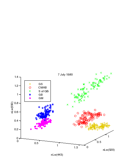
Northwest Atlantic Water Types
This analysis of optical water types in the northwest Atlantic focused
on the Georges Bank / Gulf of Maine area, but included water types farther
south for context. For this initial study, geographic locations were subjectively
selected based on general knowledge of the hydrography and bathymetry,
combined with examination of CZCS imagery from
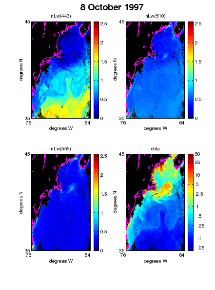
7 July 1980 and SeaWiFS imagery from 8 October
1997. Georges Bank appears as a region of high pigment in both images.
Normalised water-leaving radiances (nLw) are given in mW/(sr·cm2·mm),
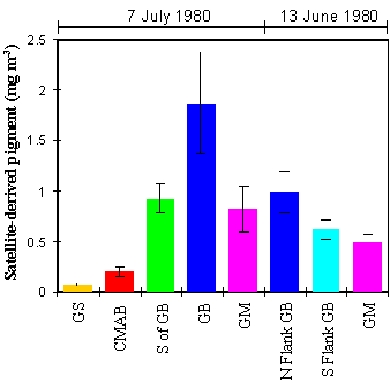
pigment concentrations are given in mg/m3. Five locations were
considered: Gulf Stream waters (GS), Central Mid-Atlantic Bight
waters (CMAB), waters located just south of Georges Bank (S of
GB), waters on Georges Bank (GB), and Gulf of Maine waters (GM).
Normalised water-leaving radiances at 443 nm, 520/510 nm, and 550/555 nm
were extracted from the CZCS/SeaWiFS images for randomly selected pixels
from each of these five locations. The data was then projected in a three-dimensional
feature space, and five distinct clusters were identified in the 7
July 1980 cluster diagram and the 8 October
1997 cluster diagram.
The water types characteristic of these five northwest Atlantic locations
are easily distinguishable in the cluster diagrams, and project onto the
same regions in feature space over time. For example, the waters over Georges
Bank (GB) occupy the same region in feature space in 1997 as they
did in 1980, although the derived pigment concentration is much higher
in 1997 than in 1980. This would indicate that the identifying characteristics
of each water type are independent of pigment concentration, and that these
characteristics are conserved over time, making these features useful for
long-term studies of water type evolution. In 1997, the S of GB
waters appear closely related to the nearby GB and GM waters.
The presence of a separate and distinct S of GB cluster in 1980
could be attributable to an episodic event (e.g. a coccolithophore bloom).
The application of an automatic water type classification scheme to a long
time-series of imagery would allow better characterisation of normal seasonal
and annual variability.
Feature-based clustering and classification can be used to study temporal
variability by tracking optical water types through time. A cluster
diagram for 13 June 1980 shows the projection of CZCS data for waters
on and around Georges Bank on that day, one month earlier than the satellite
image and cluster diagram from 7 July 1980. Since the cloud-free region
did not extend as far south as in the July 1980 image, analysis of the
June 1980 image was restricted to 3 locations: the North Flank of Georges
Bank (which on that day, was characterised by striations in ocean colour
that are thought to be biologically relevant, but caused by physical processes
(Yentsch et al. 1994)), the South Flank of the Bank, and the Gulf of Maine
waters nearby. These three water types are clearly distinguishable in the
cluster diagram, and are different from waters in the same locations a
month later.
Gulf of Maine In-Situ Optical Data
In situ data from the Gulf of Maine was collected on a research cruise aboard the R/V Endeavor from 8-18 October 1997. Sampling conducted on the cruise included water collection at several depths during CTD casts, as well as measurements of the vertical profiles of downwelling irradiance and upwelling radiance using a free-falling spectral radiometer (Satlantic SPMR/SMSR system). Both the CTD casts and radiometer work were conducted at mid-day on each day of the cruise. The cruise track and station locations are superimposed on an image of satellite-derived chlorophyll a for 8 October 1997:
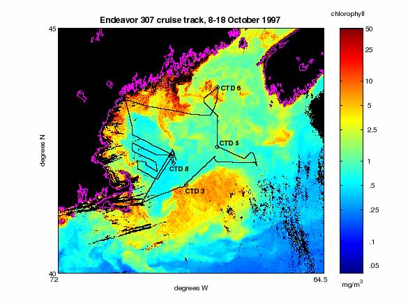
Data from four of these CTD stations can be viewed by choosing a station from the list below:
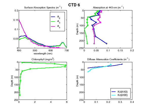
Spectrophotometric determinations of particle absorption were made both before and after extraction of phytoplankton pigments, whereas dissolved absorption was measured on 0.2 mm filtrate. The surface absorption spectra plotted in the upper left panel for each station represent the average of samples shallower than 10 m (ap denotes absorption by particles, af is the contribution by phytoplankton pigment, and as is the absorption by the dissolved component). The absorption depth profiles (upper right panel) are for absorption at 443 nm. Pigment samples were extracted in acetone, and chlorophyll a concentrations were measured spectrophotometrically (lower left panel). The diffuse attenuation coefficients (Kd) at 443 nm and 490 nm are plotted in the lower right panel.
The waters sampled at CTD 5 and CTD 8 in the Gulf of Maine are different from those at CTD 3, close to Georges Bank. In particular, the absorption by dissolved substances is considerably higher on and near the Bank versus in central Gulf of Maine. A subsurface chlorophyll maximum is also evident at CTD 3, but absent at CTD 5 and CTD 8. The pocket of high pigment waters near CTD 6 does not appear to be characteristic of the Gulf of Maine, since its properties are similar to those of CTD 3, on the edge of Georges Bank. To quantify these changes in water properties, we have integrated several optical instruments into a towed body, the BIOMAPER II, which can be towyoed up and down through the water column. These continuous measurements of absorption, attenuation, downwelling irradiance, and upwelling radiance along the cruise track will enable us to determine the geographical boundaries between optical water types in situ.
Directions for Future Research
Our preliminary work demonstrates the ability to use ocean colour data to distinguish between northwest Atlantic water types in summer and autumn, including those waters occurring within a spatially restricted region such as Georges Bank, where the interaction of tidal flow with complex bottom topography can result in the formation of fronts between different water types. We have also established the basis for developing a comprehensive approach to optically classify several different phytoplankton bloom types simultaneously by automatically distinguishing them from each other.
Our next steps in the development of feature-based optical water type classification techniques include the rigorous definition of water type classes, the formalisation of class boundaries, and the development and application of statistical decision rules for classification. As an extension of our feature-based work, we will also explore a hybrid classification approach, which will involve integrating model-based inversion techniques and feature-based classifiers. The advantage of a hybrid technique is that it can capitalise on the predictive power of existing semi-analytic models, while taking advantage of the intrinsic features in the data, which are independent of assumptions inherent in the models. Development of classification techniques for northwest Atlantic water types will be carried out in the context of in situ data collected during the ecological and hydrographic work in progress for the GLOBEC Georges Bank program, as well as our current research examining in situ optical variability in this region. Application of these classification techniques will contribute to the interpretation of the underlying properties that define optical water types, and will facilitate examination of spatial and temporal variability in water types using satellite ocean colour imagery.
Acknowledgements
We are indebted to several generous people for making this work possible. Thanks to Mark Abbott, Barney Balch, Chris Brown, Steve Groom, Pat Holligan, John Ryan, and Curt Vandetta, who provided in situ data or processed CZCS imagery for the phytoplankton bloom work. John Ryan also processed the 1980 CZCS image for the northwest Atlantic. Many thanks also to Jim Acker, Dan Ziskin and Frances Bergmann at the Goddard DAAC, and Karen Baith and Gary Fu of the SeaDAS development group, for all their help. Thanks to the captain and crew of the R/V Endeavor, as well as the other members of our lab, Anne Canaday and Rebecca Green, for their work on the in situ data from the October 1997 Gulf of Maine cruise. This work was supported in part by grants from the NASA Ocean Biology/Biogeochemistry Program (LVMT) and the ONR Environmental Optics Program (HMS).
References
Balch, W.M., R.W. Eppley, M.R. Abbot and F.M.H. Reid. 1989. Bias in satellite-derived pigment measurements due to coccolithophores and dinoflagellates. J. Plankton Res. 11: 575-581.
Borstad, G.A., J.F.R. Gower and E.J. Carpenter. 1992. Development of algorithms for remote sensing of Trichodesmium blooms. pp. 193-210 in Carpenter, E.J., D.G. Capone and J.G. Reuter (eds.) Marine Pelagic Cyanobacteria: Trichodesmium and other Diazotrophs. Kluwer.
Brown, C.W. and J.A. Yoder. 1994. Coccolithophorid blooms in the global ocean. J. Geophys. Res. 99: 7467-7482.
Eppley, R.W., F.M.H. Reid and E. Stewart. 1984. Length of phytoplankton species patches on the Southern California Shelf. Continental Shelf Research, 3: 259-266.
Holligan, P.M., M. Voillier, M., D.S. Harbour, P. Camus and M. Champagne-Philippe. 1983. Satellite and ship studies of coccolithophore production along a continental shelf edge. Nature 304: 339-342.
Sathyendranath, S., T. Platt, E.P.W. Horne, W.G. Harrision, O. Ulloa, R. Outerbridge and N. Hoepfner. 1991. Estimation of new production in the ocean by compound remote sensing. Nature. 353: 129-133.
Yentsch, C.S., D.A. Phinney and J.W. Campbell. 1994. Color banding on Georges Bank as viewed by coastal zone color scanner. J. Geophys. Res. 99: 7401-7410.
This page created and maintained by Linda
Martin Traykovski (click here to visit my home page)