Please note: You are viewing
the unstyled version of this website. Either your browser does not support CSS
(cascading style sheets) or it has been disabled. Skip
navigation.
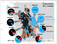
The bedrock geology of the Fraser River drainage basin is color-coded according to rock type (blue - stratified, mostly marine sediments, yellow - continental sediments, black - volcanic rocks, red - felsic intrusive rocks, pink - metamorphic rocks, dark green - ultramafic rocks). The pie charts indicate the composition of tributary river basins to the Fraser River main stem. The numbers indicate the average age of the bedrock in the tributary basins in millions of years. The map emphasizes the contrast between the sediment-dominated, mostly Phanerozoic rocks of the western Rocky Mountains and the Coast Range that is dominated by young volcanic rocks. This map was created by combining digital outlines of the Fraser River basin and its subbasins (British Columbia Fisheries Service) with the digital geologic maps of Canada and the conterminous United States of America at scales of 1:5,000,000 and 1:2,500,000, respectively. (Courtesy of Mark W. Miller, Benchmark GIS Services) Originally published: January 25, 2008 Last updated: January 11, 2011 | |||||||||||||||
Copyright ©2007 Woods Hole Oceanographic Institution, All Rights Reserved, Privacy Policy. | |||||||||||||||