| |
| | | RAFOS floats are designed to take measurements of temperature, salinity, and pressure in layers of ocean water one to three thousand meters below the surface. Each weighs about 10 kilograms, and can be carefully lowered over the side of a vessel by one person. Often two people deploy it using ropes around the glass housing and a quick release 'launching clip' that frees the ropes once the float reaches the water.
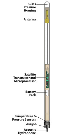
The float's electronics are housed in a 6.5 foot (two meter) glass tube. Glass is used to house the instrument because it is relatively inexpensive and is extremely strong under pressure. The glass used for making RAFOS floats is about ? inch (7 mm) thick. An additional benefit of using glass is that the antenna can be contained inside the glass and still transmit data to the satellites.
An acoustic hydrophone 'listens' for sound signals in the ocean, recording the time the signals take place. These sounds can come from anything; ship noise or moored sound sources. The recorded signals are then compared, or correlated, with a signal pattern that matches that of the sound sources. The best matching signals from each listening cycle (varying from a few hours to a few days) are stored in the float?s memory, for transmission at mission's end.
The saved sound signal data are called times-of-arrival (TOAs), and by knowing the positions of the sound sources, the sound velocity in the ocean, and the lengths of time it took to hear each source, the float's position can be triangulated for each listening cycle. These float positions are used to reconstruct the float's journey along deep ocean currents.
The float is ballasted by a stainless steel weight. At the end of a mission, lasting from nine months to two years, the float drop its weight by sending an electrical pulse to a wire that burns and releases the weight. The now-buoyant float rises to the ocean surface and beams its data via the antennae to orbiting satellites. () |